
State Wildlife Action Plan - Monitoring
This section includes information on the required element:
Element 5: descriptions of the proposed plans for monitoring species and their habitats identified in the first element, for monitoring the effectiveness of the conservation actions in the fourth element, and for adapting these conservation actions to respond appropriately to new information or changing conditions.
Overview
This section describes the process of adaptive management, a synopsis of habitat and species monitoring efforts, and opportunities for storing data that will be collected or compiled through implementation of the SWAP. These monitoring components complement each other and will provide a more comprehensive assessment of the efficacy of the SWAP.
Developing a multifaceted statewide monitoring program has many challenges. North Dakota is a large state of roughly 45 million acres, with about 90% held in private ownership. Approximately 600 species of vertebrates spend at least a portion of their life cycle within this geographic area. Roughly 120 - 150 of these species (largely game species) have varying degrees of monitoring or survey work conducted on them by several agencies. The two principal agencies that conduct much of that monitoring are the North Dakota Game and Fish Department and the U.S. Fish and Wildlife Service. The U.S. Forest Service, U.S. Army Corps of Engineers, U.S. National Park Service and various universities conduct lesser amounts. Most of the remaining 450 vertebrate species receive considerably less monitoring. Now with the addition of a host of invertebrates to the SWAP it includes more challenges. Most surveys conducted for these species are somewhat disjointed and/or are secondary in terms of monitoring objectives. A shortage of resources frequently limits the degree and scope of surveys which are initiated. In some instances, volunteers or private citizens with bird watching or similar interests carry out monitoring efforts. For example, each year the U.S. Geological Survey coordinates the annual Breeding Bird Survey, and the National Audubon Society coordinates a Christmas Bird Count; both are conducted largely by volunteers. Other examples include reptile and amphibian inventories on national parks and grassland bird surveys on fish and wildlife refuges.
There is no existing framework that can be easily modified to implement a monitoring plan for all the state’s indigenous species and their habitats. Developing a monitoring plan for North Dakota’s SGCN and habitats will require a multifaceted approach that includes but is not limited, to amalgamating the information from existing monitoring efforts to create a central reporting system and repository, modifying or expanding current surveys to include species of greatest conservation need where feasible, and implementing new monitoring efforts.
Perhaps most important to developing a statewide monitoring plan is pooling or sharing past, present and future survey information collected in North Dakota by land management agencies, universities, non-government organizations, the public, etc. Individually these monitoring efforts are somewhat small, infrequent, and often conducted on a local spatial scale (e.g. refuge or park). However, when information from these surveys is viewed collectively, or in conjunction with other surveys over time, meaningful presence, absence, range and distribution data can be generated. It is clear there will be a need to work cooperatively with these agencies, and across state lines, to coordinate monitoring efforts. The Midwest Landscape Initiative (MLI) is a coalition of state wildlife agencies and organizations in the 13 states of the Midwest Association of Fish and Wildlife Agencies (MAFWA). In November 2024, the MLI finalized Inventory and Monitoring Resources for Midwest SWAPS and Regional Conservation Planning to help inform Midwest SWAP monitoring.
Adaptive Management
Adaptive management (Hollings 1987) is an iterative process to improve the speed with which we learn and incorporate that learning into management and planning. Adoption of adaptive management inherently makes the leap from implicit uncertainty in the knowledge of the systems under management, to explicit acknowledgement of key uncertainties about systems and management of those systems. Identifying and reducing the number of key uncertainties becomes an objective of system management.
There are several requirements or steps to building and adopting an adaptive management system. They are:
- Managers include scientists and stakeholders in planning of programs and developing of measures of effectiveness. In so doing three key elements are identified:
- Measurable indicators of system responses to management alternatives.
- Policies, programs or activities that will affect the system.
- Ecological processes that link management actions to changes in the measurable indicators.
- Develop tools to predict outcomes from a suite of management alternatives.
- Identify key uncertainties in the system.
- Develop and implement management actions.
- Monitor indicators or proxies for responses to management actions.
- Evaluate information gathered during monitoring. This process includes reporting of consequences, development of recommendations to the management and stakeholders, and further refinement of key uncertainties and measurable indicators.
- Re-evaluation of management plans, programs or actions with stakeholders and scientists and adjusting (if necessary).
The objectives of a monitoring program are:
- To assist in establishing scientifically based priorities for allocating limited resources.
- Provide information and develop tools to assist management in decision making and planning.
- To increase our ecological understanding of species and their habitats.
- Provide data to identify and evaluate the effects of management actions and programs.
These objectives are consistent with the tenets of adaptive management, which is a system of improved management by design. Adopting an approach of proactive and flexible management is critical to the success of the SWAP. Functionally, managers have always adapted programs to better meet the Department’s objectives. The use of an adaptive management system for monitoring species and their habitats will lead to more effective management of fish and wildlife resources.
This process is best suited for selecting between or prioritizing management actions. The elements of adaptive management will be addressed under three headings: Planning; Implementation; and Monitoring and Evaluation. Planning includes setting objectives, identifying key uncertainties, identifying indicators and formulating models. Implementation is where plans become action at the habitat and species level. Monitoring and evaluation can happen at two levels, either species or habitat measurements. The monitoring focus is determined by objective, ability and practicality.
Planning
The Department has an array of resources to incorporate into the planning process. These include, but are not limited, to federal, state, non-governmental conservation organizations, universities, and other scientists. These experts all have extensive knowledge and are involved with existing monitoring programs that can contribute to the overall wildlife planning community. A series of annual workshops involving both terrestrial and aquatic experts were used to develop threats and conservation actions for CWCS in 2005. These meetings included private, state, federal and academic experts in wildlife research and natural resource management. Based on open discussions, priorities and uncertainties were identified and discussed at both the species and habitat level. This process was used again to revise the threats and conservation actions for the SWAP. In the fall of 2014, the NDGF convened the first SWAP Summit and in 2024 the SWAP Summit was repeated to review threats and conservation actions and identify emerging conservation issues (see Chapter 5). The Department recognizes that the complexity of information required to address adaptive management models for all species and habitats statewide does not exist. Through the expert workshops and SWAP planning process, the Department has amalgamated the information from all partners, as well as identified information that is lacking. Through this process the goal is to develop both qualitative and quantitative aspects of monitoring species and their habitats.
Implementation
Implementation involves following through with management and conservation actions on the landscape. From workshop and management planning efforts, either a single or suite of management actions will be developed. In a learning-modeling framework there are 3 ways to approach management alternatives. Each has differing costs in both time and money. These approaches are Trial and Error, Stepwise, and Complete Enumeration or the Horse Race approach (Figure 35). Trial and Error is a single step approach that is usually the least expensive method but can take substantially longer to evaluate programs with many alternatives for delivery. Stepwise is similar in cost to Trial and Error but can switch to an alternative without revisiting the planning process. Time is saved and monetary costs include the additional planning for alternatives. The Horse Race is the most efficient way to compare a suite of alternatives, but it can be prohibitive to implement and monitor all reasonable alternatives simultaneously. The approach best suited for each individual program or action will be used depending on logistics and budgets.
Single species management for wildlife planning, such as raptor recovery or re-introduction type efforts, is rare and expensive. Management action usually involves providing for or protecting habitat necessary to the life cycle of one or more SGCN. Understanding habitat associations, and species response to habitat manipulation, becomes crucial to the evaluation of program delivery. As implementation actions are defined, mechanisms for measuring habitat capacity and/or species response must too. The Department will work from study results, existing literature or expert opinions and workshops, to identify mechanisms for measuring the success of specific conservation actions.
Monitoring and Evaluation
Monitoring is incomplete without evaluation. Monitoring is discussed here in the context that it leads toward evaluation and is not solely the “collection of data.” Monitoring as a part of the adaptive management process is the periodic collection of data to be analyzed for the purpose of informing management on the efficacy of a program. Specifically, when possible, it is addressing the question, “Is/Are the management action/s having the intended species or habitat response?” The answers to this question are vital to the evolution of both science and management. Monitoring should be designed to help us to understand species or their habitats in a way that contributes to the ability to manage or benefit populations. Where information is lacking, it is necessary to develop demographic, range, population, and species habitat use information to begin the process of informed management planning.
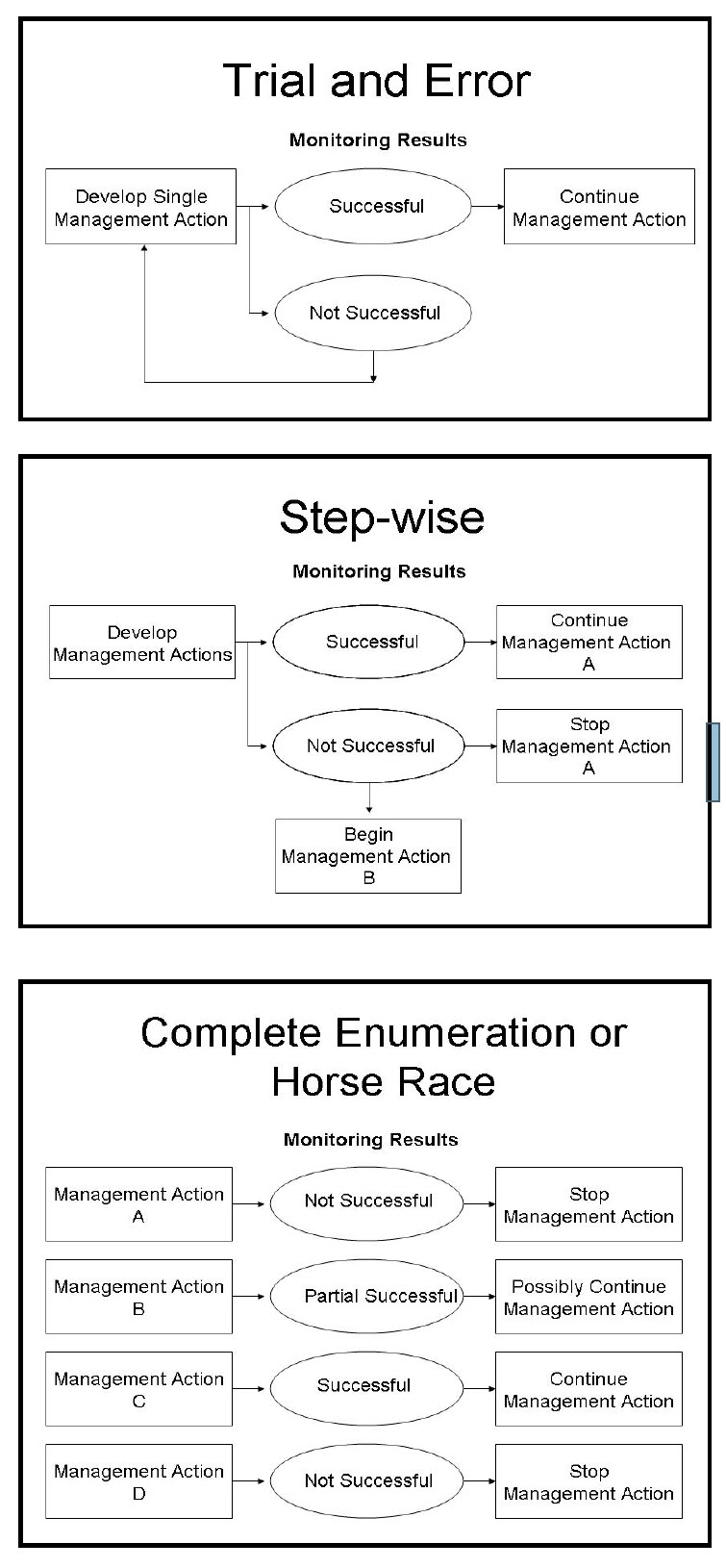
Figure 35. Visual depictions of Learning by Design (Top - Trian and Error, Middle - Step-wise, Bottom - Complete Enumeration or Horse Race).
Habitat Monitoring
North Dakota has a diversity of habitat types and conditions. Quantity and quality of habitat in relation to the larger landscape, climate, land use practices such as grazing or fire, and various other biotic and abiotic factors will affect species’ use of habitat. Many monitoring efforts focus on condition, quantity and quality of various habitats or landscapes. Most of these efforts are conducted by state and federal agencies. The following are examples of habitat monitoring that incorporate issues of scale and condition to track habitat quantity and quality over time at varying geographic scales. The Department will continue to use these monitoring efforts to assess changes in surveyed habitat.
- Four-Square-Mile Survey: In 1987, the USFWS initiated a survey to annually measure wetland habitat conditions and assess habitat use and productivity of waterfowl populations. This survey was developed by statisticians and biologists from Northern Prairie Wildlife Research Center and is administered and conducted in conjunction with USFWS HAPET offices. Conducted annually in a sub-sample of 500 foursquare mile plots throughout the Prairie Pothole Region of the U.S. (estimated 150-200 in North Dakota), and in more recent years has expanded to south and west of the Missouri River in North Dakota. The condition of habitat (e.g. wetland status, grassland, CRP) is documented in addition to waterfowl census. This effort attains habitat quantity, quality, and use information.
- Waterfowl Breeding Population and Habitat Survey for South and North Dakota: This aerial survey conducted in May of each year provides an overview of general waterfowl breeding population and climate conditions for most of North Dakota. The habitat information helps biologists make predictions as to the year’s waterfowl production but could be utilized to make inferences of breeding habitat quantity and quality for other wetland associated birds. The number of wetlands and conditions (e.g. poor, good) are documented. This effort attains habitat quantity and quality information along with population estimates.
- US Forest Service Land and Resource Monitoring: The USFS conducts a variety of habitat monitoring efforts on the Little Missouri National Grasslands, Sheyenne National Grasslands, and Cedar River National Grasslands (collectively known as Dakota Prairie Grasslands) in North Dakota. Woody draw habitat trends in the badlands, Stream and Wetland Condition, Visual Obstruction Readings (VOR), and similarity index for seral state determinations (Floristic Quality Index) are just a few examples of habitat condition monitoring the USFS conducts. These are outlined in the Dakota Prairie Grasslands Biennial Monitoring Evaluation Report. This effort attains habitat quality information.
- North Dakota Forest Health - ND Forest Service: Through a cooperative agreement with the North Dakota Forest Service, North Dakota State University Extension Service, NDSU Department of Plant Pathology, and Department of Plant Sciences, a forest health specialist has been funded for North Dakota to coordinate and direct forest health monitoring and management throughout the state. This involves conducting insect and disease surveys, providing educational outreach, and delivering training and technical assistance to natural resource professionals. This effort led to the development of the North Dakota Forest Action Plan. This serves as a strategic framework to outline priority forest resources, designate important issues, and identify strategies to address challenges and opportunities. Additionally, the Turtle Mountain Landscape Forest Stewardship Plan was developed with a goal of establishing the current baseline condition of the forested resource and identify mutual goals for future forested conditions."
- Northern Research Station’s Forest Inventory and Analysis (FIA) - US Forest Service: According to the USFS website “The Forest Inventory and Analysis (FIA) collects, analyzes, reports and distributes data about the Nation’s forests: how much forest exists who owns it, what condition it is in, where it is located, and how it has changed”. The North Research Station is responsible for inventorying more than 176 million acres of forest land spread across 3 states, including North Dakota. This information can be used in many ways, such as in evaluating wildlife habitat conditions, assessing the sustainability of ecosystem management practices, and supporting planning and decision-making activities undertaken by public and private enterprises. The FIA Program combines this information with related data on insects, diseases, and other types of forest damage and stressors to assess the health, condition, and potential future risks to forests. The Nationwide Forest Inventory (NFI) component is the best-known component of the FIA program. This component consists of a three-stage systematic sample of sites across all forested lands of the U.S.
- Watershed Management Program – ND Department of Environmental Quality (DEQ): The Watershed Management Program is primarily responsible for monitoring and assessing water quality in streams, rivers, lakes and wetlands across North Dakota. This is done by developing Total Maximum Daily Loads (TMDLs), maintaining an ambient monitoring network, conducting lake water quality assessments, conducting biological monitoring and providing technical assistance for watershed projects. Additionally, implementation initiatives such as the Nutrient Reduction Strategy, the Basin Water Quality Management Framework and information/ education programs are conducted.
- North Dakota Game and Fish Department
- Wildlife Management Area Field Mapping: The NDGF maps vegetation features and managed portions of state-owned wildlife management areas in a GIS. This effort included mapping the boundaries of fields, identifying the field status (e.g. native prairie, dense nesting cover, crop type), and activity for that year (e.g. idle, grazed, hayed, burned). This mapping effort will, over time, provide detailed, local level habitat status. This effort attains habitat quantity and quality information.
- Photo Point Monitoring: The NDGF maintains a database of photo point locations on WMAs, PLOTS, and USFS managed land. Some photographs date back to 1960, allowing for habitat change monitoring over 50+ years.
- Wildlife Management Areas Native Prairie Monitoring: Over the past several years, native prairie mapping has been done for all Wildlife Management Areas (WMAs). A total of 38,184 acres of native prairie were mapped statewide, approximately 17% of the total WMA acreage. There are grazing systems put in place on 34,389 acres, however, this is a mix of both native grasslands and replanted grasslands. In 2024, a monitoring system was put in place to begin to better understand the current conditions of the native grasslands throughout the state, with a priority given to tracts that have a current management regime (grazing system) in place. Working with the United States Fish and Wildlife Service, random transections were generated within WMA grasslands and a monitoring system was created, like that of the Native Prairie Adaptive Management protocol. Two seasonal employees were hired to collect data using the Belt Transect Method, working throughout WMAs in the western half of the state (to be continued in 2025 throughout the eastern half).
- Natural Heritage Inventory of Rare Communities – ND Parks and Recreation Department: The main purpose of the Natural Heritage Inventory is to identify North Dakota’s natural features and establish priorities for their protection. Information from the Heritage Inventory has been used to identify high quality natural areas and potential nature preserves. This effort attains habitat quantity and quality information.
Monitoring Statewide Changes in Habitat
National Land Cover Database
The Annual National Land Cover Database (NLCD) provides a seamless land cover for the entire United States for the years 1985 to 2023. There are 16 standard land cover classifications that allow for comparing land cover changes and trends over time. Changes in pixels depict a change in land cover type, or habitat type. While the NLCD is not absolute, it is considered one of the leading tools for analyzing habitat changes on a statewide basis over time. Figure 36 depicts changes from herbaceous cover (grassland, pasture, shrubland and emergent wetlands) to cultivated cropland or developed from 2015 to 2023. The map illustrates the percent change or loss of habitat per 1 square mile that has occurred since the 2015 SWAP. Despite the collaboration among various partners to implement conservation strategies aimed at protecting, restoring, and enhancing habitats, these measures have not kept pace with the widespread habitat loss that has occurred in the past 10 years.
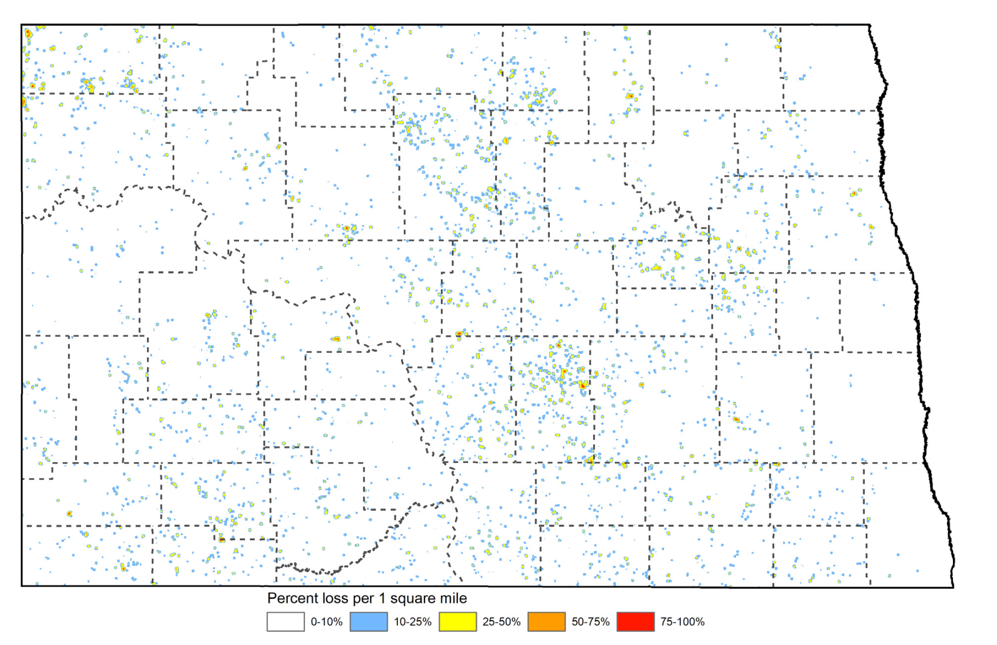
Figure 36. Change in grassland, shrubland, pasture and emergent wetland land cover classes to cultivated crops or developed land cover classes, from 2015 to 2023. Illustrated as percent change or loss of habitat per 1 square.
Wetlands
Of the nearly 5 million natural wetland acres, 60% have been lost or converted. Furthermore, the conversion of grasslands and changes in wetland hydrology, influenced by wetland drainage and consolidation, along with climate and alterations in land use, have had profound and lasting effects on the prairie and wetland ecosystems (Figure 37). See Case Study 3.
Figure 37 (below). Illustration of hydrologic shifts in wetlands from 2004 to 2024.
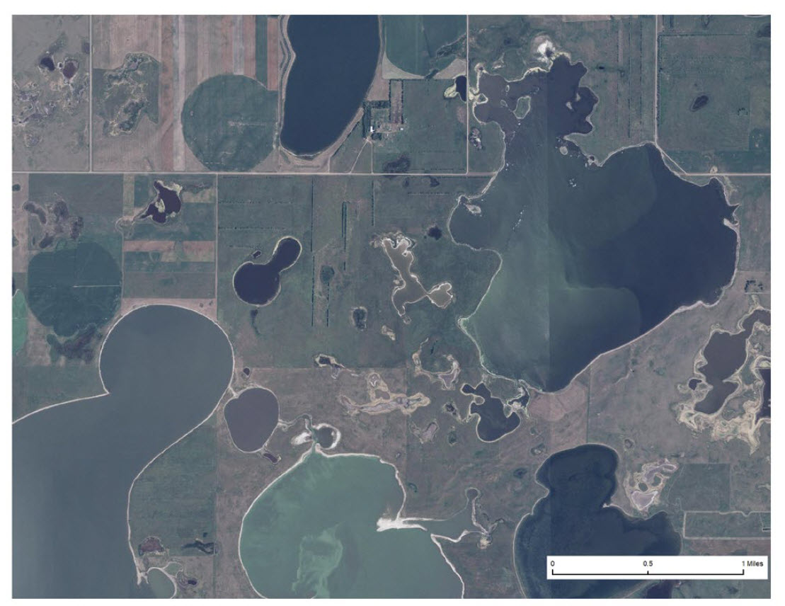
2004 aerial image of central Kidder County. More intact grasslands, wetlands, and abundant shoreline habitat availability for species such as Piping Plover.
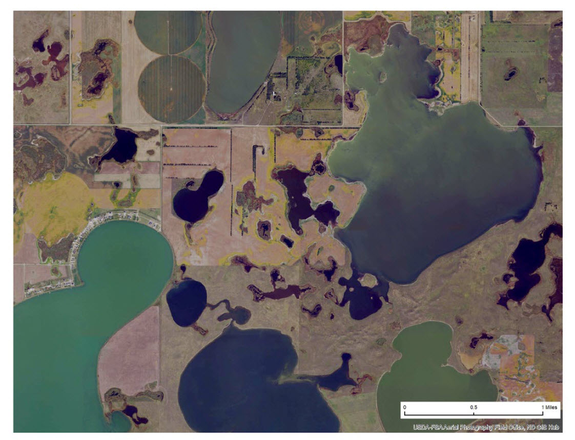
2024 aerial image of central Kidder County. Landscape changes can cause a shift towards more permanent and full lakes, a phenomenon referred to as lakefication.
Conservation Reserve Program
The USDA Conservation Reserve Program (CRP) has a significant positive impact on soil, water, and habitat conservation, making it one of the most remarkable conservation and wildlife success stories in North Dakota. Landowners can participate in various CRP practices, from planting native or introduced grasses to creating filter strips or specialized habitats like pollinator areas. The program’s positive effects on wildlife, including increased waterfowl populations and improved grassland bird nesting, are well documented. CRP grasslands can be found in every county, ranging from near-pristine native grasslands to areas dominated by non-native species like Kentucky Bluegrass and Smooth Brome. Despite some CRP lands declining in quality over time, they still provide critical breeding and wintering habitats for numerous wildlife species. At its peak in 2007, CRP enrollment reached 3.38 million acres, but it has since declined by 63% to 1.24 million acres as of 2022 due to factors such as shifts in agricultural practices, lower rental rates, and reduced acreage caps (Figure 38). This decline has had a detrimental effect on many species of greatest conservation need and species of greatest inventory need. A stronger focus on working lands, an increase in rental rates, and a higher acreage cap may be needed to reverse this trend.
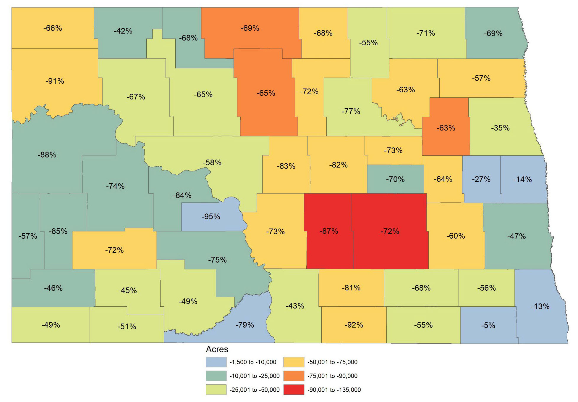
Figure 38. Percent loss of CRP general and continuous enrollment acres from 2007 to 2022.
Species Monitoring
Species specific research and survey efforts, needs, and monitoring plans may be found in Appendices A-F.
Birds
There are 57 species of birds listed as SGCN, and 11 species listed as SGIN. This represents the largest group of taxa on the list, and some of the more commonly studied and/or monitored species. See Appendix A for species specific monitoring efforts. The USFWS and USGS are two key partner agencies that state wildlife agencies collaborate with on various bird monitoring programs. In March 2025, bird experts that work in North Dakota were asked for feedback on the significance of various bird monitoring programs and efforts in North Dakota. Experts were asked to score from 1 (least important) to 5 (extremely important) for maintaining or expanding various bird monitoring efforts in North Dakota. Some of the programs listed are well-established, while others have been minimally or never implemented in the state. See Appendix A for species specific monitoring efforts.
Extremely Important - Bird Survey/Monitoring Efforts to Maintain or Increase (in order from highest to lowest)
- Breeding Bird Survey – the best long-term population trend data for most breeding birds. Ensuring that all 44 BBS are executed every year is essential, and to strategically create new routes where needed.
- Waterfowl Breeding Population and Habitat Survey – critical for Adaptive Harvest Management and long-term trends of waterfowl populations.
- Four-square Mile Breeding Waterfowl Survey – critical for allocation of conservation resources.
- Lek Surveys – crucial for monitoring prairie grouse and good indicator nesting habitat quality and availability.
- eBird – demonstrates potential for various applications, yet there is a need for more skilled users to enhance its effectiveness.
- North American Bird Banding Program/Bird Banding Lab – critical national program for management of migratory birds and estimating vital rates, but should be used in targeted situations.
Important - Bird Survey/Monitoring Efforts to Maintain or Increase (in order from highest to lowest)
- Integrated Monitoring in Bird Conservation Regions – currently occurring in limited region of ND. Potential to survey areas typically not sampled and collect valuable data, but could duplicate other efforts that are less costly.
- Long-billed Curlew Survey – specialized survey but could be adapted to better complement other efforts (e.g., BBS).
- GPS or Satellite Tracking – valuable tool for species specific research needs.
- Raptor Nest Inventory – important to maintain for infrastructure siting and reducing impacts to sensitive raptors.
- Multi Species Inventory & Monitoring – not currently implemented in ND but would produce substantial dataset of species occupancy.
- Colonial Waterbird Inventory – periodic inventory (e.g. every 10 years) to track change in colony locations and size would be valuable.
- International Shorebird Survey – not currently implemented in ND. Necessary shorebird identification skills and fluctuating nature of suitable habitats might pose challenges for conducting surveys, yet the survey may provide valuable insights into at-risk shorebird populations.
Lower Importance - Bird Survey/Monitoring Efforts to Maintain or Increase (in order from highest to lowest)
- Inventory & Monitoring of Secretive Marsh Birds – not currently implemented in ND or possibly elsewhere. Methods could be used in future studies or improved with ARUs.
- Breeding Bird Atlas – interest exists in conducting a follow-up on Breeding Birds of North Dakota (Stewart, 1975), but number of people/birders and financial resources are limited.
- Integrated Waterbird Management & Monitoring – not currently implemented in ND. The Four-square Mile survey achieves similar outcomes and is regarded as a more effective survey.
- Motus Wildlife Tracking System – currently few towers in ND. It can best be utilized with targeted and species specific research needs.
- MAPS Program – currently one station in ND. Labor and time intensive but the program is valuable for assessing demographic information, especially if it targeted SGCN or SGIN.
- Nightjar Survey Network – not currently implemented in ND. Useful survey but few nightjar species in ND, and only one on SGIN list.
- Christmas Bird Count – positive effort to encourage birding as an outdoor activity, but limited use for managing wintering birds in ND.
- Breeding Shorebird Survey – specialized survey with specific objectives. The BBS achieves similar outcomes.
Additional Actions for Birds
- Future monitoring should follow recommendations North American Bird Conservation Initiative ‘Opportunities for Improving Avian Monitoring’.
- Consider employing Autonomous Recording Units (ARUs) in existing and future monitoring/survey efforts.
- Explore the potential for surveys to address a wider range of birds, for instance, Piping Plover monitoring could also apply to other shorebirds that breed in the same areas.
Amphibians and Reptiles
There are 2 species of amphibians, and 4 reptiles listed as SGCN, along with 4 amphibians and 8 reptiles listed as SGIN. There is no statewide monitoring effort in place. A monitoring system using presence/absence data will produce distribution trends over time. See Appendix B for species specific monitoring efforts.
Existing Surveys
- Reptiles and amphibians have been surveyed recently by North Dakota State University on select state Wildlife Management Areas.
- Smaller local surveys are being conducted by state universities. Records can be tracked in the NDGF nongame database.
- Citizen based reports are collected by private organizations such as Herpmapper.
National Surveys
Several national organizations have developed standardized monitoring protocols. Once these protocols are adopted as national standards, they could serve as potential monitoring schemes to consider for North Dakota.
- PARC - Partners in Amphibian and Reptile Conservation http://www.parcplace.org/
- ARMI – Amphibian Research and Monitoring Initiative http://armi.usgs.gov/
- NAAMP – North American Amphibian Monitoring Program https://www.usgs.gov/centers/eesc/science/north-american-amphibian-monitoring-program
Amphibian and Reptile Monitoring/Survey Goal
- No statewide monitoring effort is currently in place. Collaboration with NDSU to develop a citizen science-based monitoring protocol has occurred.
Mammals
North Dakota’s SWAP includes 12 SGCN and 14 SGIN mammal species. A monitoring protocol for mammals, especially small mammals, has been identified as one of the greatest needs for mammal conservation. It was agreed that a monitoring system using presence/absence data to develop trends would be the most effective means for tracking changes in small mammal distribution over time. The NDGF has identified this as a major need in this SWAP and will continue to develop a monitoring protocol. See Appendix C for species specific monitoring efforts.
Existing Surveys
- Swift fox will be monitored by the NDGF.
- Black-tailed Prairie Dogs (BTPD) are monitored as part of a range-wide survey as stated in the North Dakota Black-tailed Prairie Dog Management Plan. The USFS Dakota Prairie Grasslands and Theodore Roosevelt National Park survey their lands for BTPD.
- Presence/absence of Black-Footed Ferrets will be noted during black-tailed prairie dog surveys.
- University research includes local level projects, typically on targeted species.
Mammal Monitoring/Survey Goals
- Development of an acoustic monitoring plan for bats is in development by the ND Bat Working Group, a group of state partners that includes the NDGF.
- The NDGF will partner and share information with various agencies where opportunities exist to best monitor mammal populations.
- The NDGF incidental reporting system will be used to augment data on mammal populations.
- The NDGF will continue work to develop a monitoring protocol to track species within the state.
- The NDGF will develop a protocol such that future funded research may be combined with other independent studies for more robust estimates based on sample size.
Fish
North Dakota’s SWAP includes 16 SGCN and 3 SGIN fish species. Many of these species can be monitored by niche based upon habitat needs, such as riffle stream fishes. The list also includes species that must be monitored individually due to habitat preferences (e.g. Blacknose Shiner) or small population (e.g. Pallid Sturgeon). See Appendix D for species specific monitoring efforts.
Existing Surveys
- The NDGF partners with VCSU to survey select streams on a yearly basis.
- The NDDEQ IBI stream surveys and prairie fish surveys cover substantial reaches of major rivers in the state.
- Individual species monitoring, such as for pallid sturgeon, are conducted by partnering agencies.
- NDGF conducts annual surveys for young-of-the-year paddlefish and tags adult paddlefish.
Fish Monitoring/Survey Goals
- SGCN fish species are monitored with a combination of annual lake and river/stream surveys.
Invertebrates
Invertebrates are the largest taxa group in North Dakota. Freshwater mussels have been included in the SWAP since its original development in 2005. In the 2015 revision, three butterflies were added. This edition will be the Department’s first effort to include aquatic insects and a more robust evaluation of terrestrial insects. The NDGF does not currently monitor insect populations internally, but by working with and supporting partners, has begun to compile information, identify data gaps, and work towards a better understanding of population trends.
Terrestrial Invertebrates
Twenty-three terrestrial insects are identified as SGCN with another 37 listed as SGIN. See Appendix E for species specific monitoring efforts.
Insect Monitoring/Survey Goals
- Continue to compile insect data.
- Presence/absence
- Range and distribution
- Develop monitoring protocols for species added to the SGCN list.
Aquatic Invertebrates
Insects are the largest taxa group in North Dakota and ten specific taxa have been incorporated as SGCN. The NDGF does not monitor insect populations currently but recognizes the importance of gathering this information. The lack of information on insect populations is a daunting task to overcome. The NDGF has started to compile known information to identify the most important data gaps. The Department also plans to begin evaluating aquatic insect assemblages on waterbodies associated with state Wildlife Management Areas. See Appendix F for species specific monitoring efforts.
Existing Surveys
- No existing NDGF annual surveys are in place, but development of standardized surveys are currently planned.
- The NDDEQ surveys aquatic insects as a part of an IBI development and stream assessment program for prairie streams.
- University research conducts surveys on a local level.
Insect Monitoring/Survey Goals
- Continue to collect data to develop range and distribution on aquatic SGCN.
Freshwater Mussels
Ten species of mussels are listed as SGCN. This represents two thirds of the species known to inhabit North Dakota. Freshwater mussels have been surveyed by VCSU through various SWG projects, and a framework monitoring protocol was developed. See Appendix F for species specific monitoring efforts.
Existing Surveys
- Freshwater mussels will be surveyed periodically by contract to track populations.
Freshwater Mussel Monitoring/Surveys Goals
- Implement a monitoring protocol to evaluate freshwater mussel species within the state using information gathered during opportunistic SWG projects.
Threatened and Endangered Species
There are twelve federal threatened or endangered species on the SGCN or SGIN list. These include Whooping Crane, Piping Plover, Red Knot, Pallid Sturgeon, Black-footed Ferret, Northern Long-eared Bat, Suckley’s Cuckoo Bumble Bee, Rusty Patched Bumble Bee, Monarch Butterfly, Regal Fritillary, Poweshiek Skipperling, and Dakota Skipper.
Existing Surveys
- Whooping Crane: spring and fall migration sightings are reported to the USFWS or NDGF Migratory Game Bird Biologists.
- NPWRC is leading research and survey efforts on Piping Plovers.
- The USACE conducts annual monitoring of Piping Plovers and Least Terns along the Missouri River System.
- The USFWS monitors Pallid Sturgeon in the Missouri River system.
- Black-footed Ferrets are considered extirpated but would be reported if sighted during Black-tailed Prairie Dog surveys.
- Black-footed Ferrets identified in the Department’s Furbearer Observation Report will be investigated.
- Dakota Skipper are currently monitored closely at known sites as well as potential sites identified by surveyors.
- Several partners survey bats annually in the state. Northern Long-eared Bats are report to the USFWS.
- Pollinators have been surveyed by NDSU, USGS Northern Prairie Wildlife Research Center, and USFWS HAPET.
Monitoring Conservation Actions
Understanding species response to conservation actions is crucial to program delivery. As SWG funded conservation actions are implemented, monitoring the effectiveness of the actions will be a requirement of each project. Each project will identify specific objectives, deliverables, and a plan, including the appropriate geographic scale, for how it will be monitored. Monitoring may be limited or less frequent for those conservation actions that have demonstrated beneficial effects. Conservation actions that do not meet the project’s objectives will be reevaluated. In addition to SWG funded conservation actions, partners will be encouraged to monitor conservation actions affecting SGCNs and associated habitat.
Databases
Databases of existing and newly obtained information allows the Department and partners to evaluate conservation actions and conservation goals based on the best available information. This will be a key component in maintaining efficient adaptability of the state’s plan as we progress into the implementation phase. It will also provide enhanced accessibility and additional information to be used in revisions of the state’s SWAP. There are several options for storing and obtaining spatial data and other information to support habitat and species monitoring efforts. Databases or opportunities which will be used are presented below.
ND Game and Fish Department Spatial Database
The nongame database was developed to maintain spatial information on SGCN and other nongame species. Data incorporated into the nongame database is derived from several sources including SWG projects, Department survey efforts, Scientific Collection reports and the public. This information is used to augment other monitoring efforts to bolster knowledge of these species. The Department also maintains an extensive database of fish and wildlife information which is available only to Department staff. Examples include grouse lek sites, nongame fish stream sampling, Black-tailed Prairie Dog towns, or telemetry data. GIS databases will continue to grow in use for maintaining species and habitat information.
North Dakota GIS Hub
The North Dakota GIS Hub was created in 2001 because of widespread demand from state agencies wanting a mechanism for sharing the great amount of GIS data useful to many agencies. The GIS Hub provides easy and quick access to a large amount of geographic information such as aerial imagery, land cover, topography, National Wetlands Inventory, statewide parcel dataset, federal and state land ownership, roads and more. All data is available for download and can be accessed. The ND GIS Hub may be found at https://www.gis.nd.gov/
The North Dakota Natural Heritage Program
Within North Dakota, the ND Parks and Recreation Department (NDPRD) Natural Heritage Program has served as a repository for rare and unique species and habitat information. However, a lack of funding and other resources has limited the effectiveness of the program with respect to data entry, retrieval and the ability of staff to network with those who carry out monitoring and survey efforts across the state. The Department provided the Natural Heritage Program with a state wildlife grant to upgrade its software to allow for more efficient data entry and retrieval. The Natural Heritage Program serves as the primary repository for plant information and the Department is the primary repository for wildlife information. In 2010 the Natural Heritage Program staff developed a list plant species of conservation priority and completed a species account for each, including conservation threats and actions. Although the SWAP may include information on plants, use of SWG funding restricted to wildlife and their habitats. Nonetheless, plants compose habitat, and many species are rare and/or declining. The supplementary plant document may be requested from the Department or NDPRD.