

Badlands
Description and Key Features
This landscape encompasses the area associated with the Little Missouri River drainage, commonly known as the Badlands.
This highly dissected terrain was shaped by water erosion of soft silt or clay soils and the collapse following lignite coal bed fires.
Badly eroded clay-scoria slopes, buttes, and steep canyons are prevalent throughout the region.
Thickets of small trees and shrubs, or woody draws of cottonwood and green ash, naturally occur on north- or east-facing escarpments.
Bare hills, scattered with Rocky Mountain juniper, and shortgrass prairie dominate the bottomlands and tops of buttes.
A few small, unique stands of native coniferous forest are found, specifically in Billings, Golden Valley, Slope, and Bowman counties.
The absence of fire has allowed juniper to expand and encroach upon some areas.
Ephemeral or intermittent streams are common in steep valleys, while natural wetlands are rare; however, water impoundments are abundant.
Cattle grazing is the most prevalent land use, but the area is a popular destination for outdoor recreation such as hunting, hiking and biking.
Oil and gas development has occurred in this region since the 1950s but has intensified since around 2009.
The Killdeer Mountains and Ponderosa Pines Focus Areas lie within the Badlands’ exterior boundaries but are categorized under Upland Forest.
The Badlands has abundant caves or crevices, or naturally occurring cavities formed underground or in the face of a cliff or hillside.
In North Dakota, caves are usually not large enough for a human to enter.
However, they may be very important hibernacula and overwintering areas for bats.
Badlands Classification Relationships
The Midwest Landscape Initiative developed Voluntary Lexicon and Best Practice Recommendations for Midwest State Wildlife Action Plans (May 2024).
In line with recommendation 2.1, the following Macrogroup and Group classifications from the United States National Vegetation Classification System (USNVC) pertain to Badlands habitat in North Dakota.
- Macrogroup: M501 Central Rocky Mountain Dry Lower Montane-Foothill Forest (https://www1.usgs.gov/csas/nvcs/unitDetails/877291)
- Group: G209 Rocky Mountain Foothill-Rock Outcrop Limber Pine – Juniper Woodland (https://www1.usgs.gov/csas/nvcs/unitDetails/836637)
- Group: G213 Central Rocky Mountain Ponderosa Pine Open Woodland (https://www1.usgs.gov/csas/nvcs/unitDetails/836566)
- Group: G216 Black Hills-Northwestern Great Plains Ponderosa Pine Forest and Woodland (https://www1.usgs.gov/csas/nvcs/unitDetails/836663)
- Macrogroup: M052 Great Plains Sand Grassland and Shrubland (https://www1.usgs.gov/csas/nvcs/unitDetails/860480)
- Group: G889 Northern Great Plains Sand Grassland (https://www1.usgs.gov/csas/nvcs/unitDetails/1127110)
- Macrogroup: M115 Great Plains Badlands Vegetation (https://www1.usgs.gov/csas/nvcs/unitDetails/860626)
- Group: G566 Great Plains Badlands Vegetation (https://www1.usgs.gov/csas/nvcs/unitDetails/857182)
- Macrogroup: M116 Great Plains Cliff, Scree and Rock Vegetation (https://www1.usgs.gov/csas/nvcs/unitDetails/860694)
- Group: G567 Great Plains Cliff, Scree and Rock Vegetation (https://www1.usgs.gov/csas/nvcs/unitDetails/857191)
Badlands Map

The badlands region (black outline) and shaded relief.
Badlands Images

Badlands topography.

Badlands cattle grazing and woody draws.
Associated Species
Note: Species listed here include SWAP SGCN and game species.
| Species Image | Species | Taxon | Subtaxon or Group |
|---|---|---|---|
|
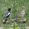
Lark Bunting | Birds | Landbird |
|
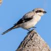
Loggerhead Shrike | Birds | Landbird |
|
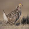
Sharp-tailed Grouse | Birds | Landbird |
|
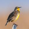
Western Meadowlark | Birds | Landbird |
|
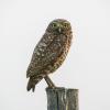
Burrowing Owl | Birds | Landbird |
|
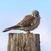
American Kestrel | Birds | Landbird |
|
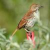
Brown Thrasher | Birds | Landbird |
|
Golden Eagle | Birds | Landbird |
|
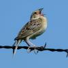
Grasshopper Sparrow | Birds | Landbird |
|
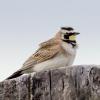
Horned Lark | Birds | Landbird |
|
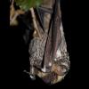
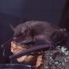
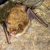
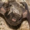
Big Brown Bat | Mammals | Bat |
|
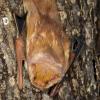
Eastern Red Bat | Mammals | Bat |
|
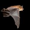
Hoary Bat | Mammals | Bat |
|
Little Brown Bat | Mammals | Bat |
|
Northern Long-eared Bat | Mammals | Bat |
|
Silver-haired Bat | Mammals | Bat |
|
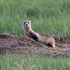
Black-footed Ferret | Mammals | Carnivore |

|
Swift Fox | Mammals | Carnivore |
|
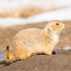
Black-tailed Prairie Dog | Mammals | Rodent |

|
Plains Spadefoot | Amphibians | Toad |

|
Hera Sheepmoth | Terrestrial Invertebrates | Moth |

|
Badlands Tiger Beetle | Terrestrial Invertebrates | Beetle |