

Soil
This habitat type is distinct because it can coexist with any other habitat. It includes any underground habitat formed entirely within mineral soil. Soil habitats are dug by burrowing species rather than created by geological forces. As a result, they are often small and temporary, filling in due to erosion and soil settling. Many species use underground burrows for various purposes, such as resting, raising young, or storing food. These species may dig the burrows themselves, take over burrows from other species, or inhabit abandoned ones. For this discussion, a species was classified as using soil habitats only if it spends most of its time in subterranean spaces.
Associated Species
Note: Species listed here include SWAP SGCN and game species.
| Species Image | Species | Taxon | Subtaxon or Group |
|---|---|---|---|
|
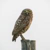
Burrowing Owl | Birds | Landbird |

|
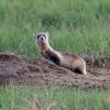
Swift Fox | Mammals | Carnivore |
|
Black-footed Ferret | Mammals | Carnivore |
|
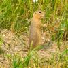
Richardson’s Ground Squirrel | Mammals | Rodent |
|
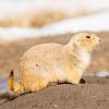
Black-tailed Prairie Dog | Mammals | Rodent |
|
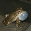
American Toad | Amphibians | Toad |

|
Plains Spadefoot | Amphibians | Toad |

|
Badlands Tiger Beetle | Terrestrial Invertebrates | Beetle |

|
Ghost Tiger Beetle | Terrestrial Invertebrates | Tiger Beetle |

|
Northern Sandy Tiger Beetle | Terrestrial Invertebrates | Tiger Beetle |