
State Wildlife Action Plan - Focus and Key Native Wildlife and Habitat Areas
In certain instances, there was enough information or justification to designate Focus Areas within specific landscapes. The EPA’s Level IV ecoregions served as the foundation for identifying these Focus Areas in the 2015 SWAP. Using Geographic Information Systems, Level IV ecoregions were analyzed alongside various land cover data, the Department’s extant native prairie/unbroken grassland and native forest, and spatial biological planning tools, including key sites for Species of Greatest Conservation Need. The boundaries of specific Level IV ecoregions were selected and adjusted (digitized) based on existing native vegetation and key biological data, highlighting areas where the highest concentration of SGCN may occur.
Focus Areas typically display distinct or easily identifiable differences in vegetation, soils, topography, hydrology, or land use. These areas are highly variable in size and often represent rare types of native vegetation or natural communities within North Dakota. Twenty-one Focus Areas were developed for the 2015 SWAP. Conservation Reserve Program (CRP) grasslands have been removed as a specific focus area in the 2025 SWAP, but CRP and other restored/planted grassland remains an important component of the grassland landscape. Therefore, a total of 20 Focus Areas are identified in the 2025 SWAP (Figure 28). Wetlands are considered a key component within these Focus Areas where they are present. The Badlands, a unique land feature, also contains designated Focus Areas, though these are categorized under other landscapes (for example, the Ponderosa Pines Focus Area is included within the Upland Forest landscape).
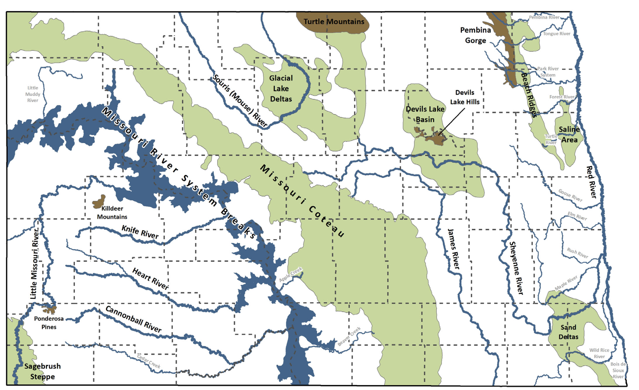
Figure 28. SWAP Focus Areas. Rivers labeled in light gray are tributaries of focus areas.
Focus Areas
Saline Area
This region is characterized by saline soils, caused by salty groundwater rising to the surface from underlying sandstone. As a result, much of the land is unsuitable for crop farming, with grazing taking place in most uncultivated areas. Salt-tolerant plants thrive here, and many of the wetlands are brackish. The area contains several large tracts of native tallgrass prairie, each over 640 acres, but most of it remains unprotected. Grand Forks County Prairie Partners advocate for its preservation, though urban expansion poses a threat, as much of the area lies within 15 miles of Grand Forks.
- Key SGCNs: Greater Prairie-Chicken, LeConte’s Sparrow, Short-eared Owl, Yellow Rail, Regal Fritillary
- Key SGINs: Arctic Shrew
Sand Deltas and Beach Ridges
Thick sand deposits, formed from river sediments carried to glacial Lake Agassiz, have created windblown sand dunes, with the largest being the Sheyenne Delta in the southern Red River Valley. The Beach Ridges run in parallel lines of sand and gravel, along with a smaller delta east of the Pembina Gorge. Some agricultural activities, including irrigation, occur in the deltas and around the beach ridges. The Sand Deltas focus area encompasses the Sheyenne National Grasslands, managed by the US Forest Service, making it the largest publicly owned tallgrass prairie preserve in the United States. Oak savannahs thrive in the delta areas, with the Sheyenne River flowing through them. Privately owned native tallgrass prairie stands are also located adjacent to the Sheyenne National Grasslands.
- Key SGCNs: American Kestrel, Greater Prairie-Chicken, Northern Prairie Skink, Plains Hog-nosed Snake, Dakota Skipper, Poweshiek Skipperling
- Key SGINs: Plains Pocket Mouse
Glacial Lake Deltas
This area, characterized by glaciated flat sheets of sand and gravel or rolling sand dunes, is largely unsuitable for cropland. The droughtprone soils are mainly used for cattle grazing, although some cropland exists, with irrigation making previously unsuitable land farmable. Wet conditions will flood portions of grassland and hayland. Tallgrass prairie communities are also present within this focus area, where the vegetative cover is sparse and dominated by species such as Little Bluestem, Indiangrass, Prairie Sandreed, Switchgrass, and Sand Bluestem.
- Key SGCNs: American Kestrel, LeConte’s Sparrow, Richardson’s Ground Squirrel, Dakota Skipper
- 3>Devils Lake Basin
Extensive wetland drainage and intensive farming dominate the northern part of the focus area due to its rich soils and relatively flat terrain. Larger wetlands and lakes are more common here, partly due to the drainage of smaller, temporary, and seasonal wetlands for agricultural purposes. Since 1993, the water levels of Devils Lake have been rising at unprecedented rates, climbing 31.68 feet to a record elevation of 1,454.3 feet above mean sea level in June 2011. This rise has flooded 167,070 acres (261 square miles) of land since 1993. The Sheyenne River meanders through the southern part of the basin, with many adjacent non-wooded uplands remaining intact.
- Key SGCNs: American Bittern, Lesser Scaup, Ruddy Turnstone, Eastern Spotted Skunk
- Key SGINs: Franklins Ground Squirrel, Arctic Shrew
Missouri Coteau
The rolling, steep topography of this area has largely prevented it from being farmed, allowing a significant portion of native prairie to remain intact. However, conversion to agriculture and industrial development is ongoing. Cattle grazing is the most common land use, and numerous wetlands of various types are scattered throughout the region. Considerable conservation efforts, particularly focused on grassland preservation, have been directed toward the Coteau.
- Key SGCNs: American Bittern, Baird’s Sparrow, Bobolink, Chestnut-collared Longspur, Ferruginous Hawk, Grasshopper Sparrow, Hudsonian Godwit, LeConte’s Sparrow, Lesser Yellowlegs, Long-billed Dowitcher, Marbled Godwit, Nelson’s Sparrow, Northern Harrier, Northern Pintail, Pectoral Sandpiper, Semipalmated Sandpiper, Sharp-tailed Grouse, Short-billed Dowitcher, Short-eared Owl, Sprague’s Pipit, Stilt Sandpiper, Upland Sandpiper, Western Meadowlark, Willet, Wilson’s Phalarope, Richardson’s Ground Squirrel, Dakota Skipper, Monarch Butterfly, Regal Fritillary
- Key SGINs: Franklin’s Ground Squirrel
Sagebrush Steppe
Eroded buttes, scoria mounds, and salt pans give this area a landscape similar to the badlands. The characteristic big sagebrush ecosystem has been significantly altered by livestock grazing, conversion to cropland, and oil and gas development. Despite this, extensive conservation efforts over the past decade have focused on improving Greater Sage-Grouse habitat. However, the remaining fragile habitat is highly fragmented and continues to face ongoing threats.
- Key SGCNs: Brewer’s Sparrow, Greater Sage-Grouse, Long-billed Curlew, Thick-billed Longspur, Swift Fox, Hera Sheepmoth
- Key SGINs: Sagebrush Lizard, Ord’s Kangaroo Rat, Merriam’s Shrew, Sagebrush Vole
Missouri River System/Breaks
The Missouri River, the longest river in the United States, begins in the Rocky Mountains of Montana and flows southeast to join the Mississippi River in Missouri. It forms the largest river system in North Dakota. The system is divided into sections: the Upper Missouri River/Yellowstone River, Lake Sakakawea, the Missouri River below Garrison Dam, and Lake Oahe, which starts just south of Bismarck/Mandan. Secondary rivers in the Missouri River System/Breaks Focus Area include the Yellowstone River, Little Muddy Creek, Apple Creek, and Beaver Creek (at Lake Oahe). Other major tributaries, such as the Little Missouri River, Knife River, Heart River, and Cannonball River, are separate Focus Areas. The damming of the Missouri River in the 1950s significantly altered its natural flow. The River Breaks feature steep, dissected topography with woody draws, riparian forests, and upland shortgrass prairie. The loss of natural flooding, which stimulates cottonwood growth, has inhibited cottonwood regeneration. Human development and urban expansion are increasing, particularly around the Bismarck/Mandan and Williston areas.
- Key SGCNs: Least Tern, Piping Plover, Red-headed Woodpecker, Little Brown Bat, Northern Long-eared Bat, Blue Sucker, Burbot, Flathead Chub, Northern Redbelly Dace, Paddlefish, Pallid Sturgeon, Sicklefin Chub, Sturgeon Chub, Dakota Stonefly, Plains Stripetail
- Key SGINs: Red Knot, Common Gartersnake, False Map Turtle, Smooth Softshell, Spiny Softshell, Paiute Dancer
Little Missouri River
The Little Missouri River originates in eastern Wyoming and flows north through the badlands of western North Dakota. In North Dakota, Beaver Creek is a secondary Focus Area, flowing into the Little Missouri River before it eventually empties into Lake Sakakawea at Little Missouri Bay. While areas of plains cottonwood forest still occur along the riverbanks, their extent has been significantly reduced from historic levels. Juniper tree encroachment is becoming more prevalent in these cottonwood forests. Cattle grazing and unrestricted use along much of the river pose potential threats in North Dakota.
- Key SGCNs: Golden Eagle, Red-headed Woodpecker, Little Brown Bat, Northern Long-eared Bat, Flathead Chub, Northern Redbelly Dace, Sicklefin Chub, Sturgeon Chub, Plains Stripetail
- Key SGINs: Short-horned Lizard, Fringed Myotis, Long-eared Bat, Long-legged Bat, Townsend’s Big-eared Bat, Western Small-footed Bat, Winter Stonefly
Knife River
The Knife River originates in the badlands of west-central North Dakota and flows eastward for 200 miles before joining the Missouri River. The watershed faces threats from poor land use practices, leading to increased erosion and higher sediment loads. Runoff from surrounding lands contributes to water quality impairment in the watershed.
- Key SGCNs: Blue Sucker, Flathead Chub, Northern Redbelly Dace, Fragile Papershell
- Key SGINs: False Map Turtle, Spiny Softshell, Small Square-gilled Mayfly
Heart River
The Heart River flows across approximately 180 miles of western North Dakota, beginning in Billings County within the Little Missouri National Grasslands. It flows eastward, passing through the Patterson Reservoir near Dickinson, and is joined by the Green River at Gladstone, which is a secondary focus area included with the Heart River. The river continues through Lake Tschida, formed by the Heart Butte Dam, before turning northeast and flowing into the Missouri River south of Mandan. The Heart River is threatened by several land use practices, including reduced riparian width, loss of native riparian plant diversity, overgrazing of the riparian zone, stream bank erosion, and channel filling with sediments. Increased runoff from the watershed further contributes to impairment.
- Key SGCNs: Flathead Chub, Northern Redbelly Dace, Dakota Stonefly
- Key SGINs: False Map Turtle, Spiny Softshell, Spinylegs
Cannonball River
The Cannonball River flows 135 miles from west to east across southwestern North Dakota before emptying into Lake Oahe. Instream flow can vary greatly, ranging from nearly none during dry years to 95,000 cubic feet per second during wet years. Both the upper and lower portions of the Cannonball River and its tributaries are threatened by high nutrient levels and increased sedimentation, likely resulting from land use practices within the watershed. Pathogens have also been identified as impairments to the river system. Cedar Creek is a secondary river included in this focus area.
- Key SGCNs: Blue Sucker, Flathead Chub, Northern Redbelly Dace, Dakota Stonefly
- Key SGINs: False Map Turtle, Smooth Softshell, Spiny Softshell, Spinylegs
Red River and Tributaries
The Red River basin drains 39,300 square miles across a three-state region, including 21,000 acres of eastern North Dakota. Its largest North Dakota tributary is the Sheyenne River, while secondary rivers include the Bois de Sioux, Wild Rice, Elm, Goose, Turtle, Forest, Park River System, and the Tongue and Pembina Rivers. Many of these rivers are impacted by channelization and flood control impoundments, which were implemented to manage land drainage for agriculture. The region also features extensive drainage ditch systems that alter the natural hydrology of the basin. Agricultural runoff and wastewater inputs contribute further to impairing the system.
- Key SGCNs: American Toad, Gray Fox, Burbot, Blacknose Shiner, Carmine Shiner, Finescale Dace, Hornyhead Chub, Northern Pearl Dace, Northern Redbelly Dace, Pugnose Shiner, Silver Chub, Trout-perch, Dakota Stonefly, Plains Stripetail, sand-dwelling mayfly
- Key SGINs: Common Mudpuppy, Cope’s Gray Treefrog, Eastern Gray Treefrog, Wood Frog
Sheyenne River
The Sheyenne River basin spans nearly 900,000 acres, making it the largest contributing tributary to the Red River in terms of area. It originates in the mixed grass region of central North Dakota and flows southeast toward its confluence with the Red River. Agricultural and ranching practices throughout the region, along with wastewater discharge, have impacted water quality in this drainage. The construction of an outlet from Devils Lake into the Sheyenne River has altered the flow, elevation, and water quality. The Maple and Rush Rivers are secondary Focus Areas, entering the Sheyenne River near its confluence with the Red River.
- Key SGCNs: Black-billed Cuckoo, Gray Fox, Little Brown Bat, Blacknose Shiner, Carmine Shiner, Northern Pearl Dace, Northern Redbelly Dace, Pugnose Shiner, Trout-perch, Black Sandshell, Creek Heelsplitter, Creeper, Mapleleaf, Pink Heelsplitter, Threeridge, Wabash Pigtoe, Dakota Stonefly, Plains Stripetail
- Key SGINs: Common Gartersnake, Red-bellied Snake
James River
The James River begins in the Drift Prairie of central North Dakota and flows south into South Dakota. The area is primarily used for agriculture. A large reservoir north of Jamestown serves flood control and municipal needs. Land use practices and water withdrawal have been identified as threats to this river system. Many stretches of the river are impaired by high nutrient loads and sedimentation.
- Key SGCNs: Blacknose Shiner, Carmine Shiner, Pugnose Shiner, Black Sandshell, Creeper, Deertoe, Fragile Papershell, Plains Emerald
- Souris (Mouse) River
The Souris (Mouse) River originates in eastern Saskatchewan, flowing south into northern North Dakota before returning north into Canada. Water flow is regulated by two large reservoirs in Saskatchewan and several smaller dams in North Dakota. The primary land use in this drainage is agriculture. Many stretches of the river are impaired by high nutrient content and sedimentation, with wastewater discharge further affecting water quality. The region also experienced major flooding in 2011.
- Key SGCNs: Northern Pearl Dace, Trout-perch
- >Key SGINs: Long-horned Casemaker, Northern case maker
Pembina Gorge
The Pembina Gorge is a small but steep and dissected escarpment located on the edge of the Drift Prairie, bordering the Red River Valley and Canada. The area is dominated by deciduous forests, including Bur Oak, Quaking Aspen, Green Ash, Cottonwood, and American Elm. The steep slopes help preserve the natural woodland community, while the flatter areas have been cleared for cropland, including small grains, sunflowers, and flax. Off-road vehicle trail systems have been developed, and there is ongoing advocacy for more trails through the Gorge. The Pembina Gorge on the North Dakota side is likely a key migration corridor, as high numbers of raptors have been documented migrating through the Canadian side of the Pembina Valley. The Pembina River, Tongue River, and Park River System run east-west through the Gorge, while Upland Forest on flat land lies to the east in the Beach Ridges focus area.
- Key SGCNs: Black-billed Cuckoo, Ruffed Grouse, Eastern Red Bat, Gray Fox, Hoary Bat, Silver-haired Bat
- >Key SGINs: Copes Gray Treefrog, Eastern Gray Treefrog, Wood Frog, Arctic Shrew, Boreal Whiteface, Giant Case Maker
Turtle Mountains
Set in the northern Drift Prairie, the rolling topography and an additional 10 inches of precipitation per year support deciduous forest cover, including Bur Oak, Aspen, Green Ash, Paper Birch, Boxelder, Sumac, Serviceberry, and Snowberry. The Turtle Mountains rise 600 to 800 feet above the surrounding prairie and wetland landscape. The soil in this region is erodible and poorly suited for farming, although some agricultural activity does occur. Native woodland clearings have been converted into pastureland. The area is dotted with hundreds of large, deep ponds and lakes.
- Key SGCNs: Ruffed Grouse, Eastern Red Bat, Hoary Bat, Silver-haired Bat, Subarctic Darner
- >Key SGINs: Red-bellied Snake, Wood Frog, Arctic Shrew, Northern Water Shrew, Pygmy Shrew, Boreal Whiteface
Devils Lake Hills
The deciduous forest bordering Devils Lake is similar to that of the Pembina Hills, featuring Bur Oak, Quaking Aspen, and Birch. However, much of the natural forest along the shorelines of the lake has been submerged due to the recent rise in water levels.
- Key SGCNs: Eastern Red Bat, Hoary Bat, Little Brown Bat, Silver-haired Bat, Subarctic Darner
- >Key SGINs: Wood Frog, Arctic Shrew, Boreal Whiteface
Killdeer Mountains
Separated from the main stem of the badlands, the Killdeer Mountains rise 700 to 1,000 feet above the surrounding prairie landscape, with the highest point reaching 3,314 feet—about 200 feet lower than the state's highest peak, White Butte. The dominant deciduous vegetation includes Bur Oak, Quaking Aspen, Green Ash, Paper Birch, Western Black Birch, and American Elm. Grazing occurs on private land, while the Killdeer Wildlife Management Area spans the Killdeer Mountains.
- Key SGCNs: Golden Eagle, Little Brown Bat
- 3>Ponderosa Pines
Coniferous forest is rare in North Dakota, and this stand of Ponderosa Pine in the southwestern part of the state is located at the northeastern most edge of its overall range. It may be an outlier of the pines from the Black Hills of South Dakota. In the summer of 2004, a fire swept through the region, burning several hundred acres of pine. Occasional management may be necessary to prevent the encroachment of pines into native prairie.
- Key SGCNs: Little Brown Bat
- >Key SGINs: Fringed Myotis, Long-eared Bat, Long-legged Bat, Townsend’s Big-eared Bat, Western Small-footed Bat
KEY NATIVE WILDLIFE AND HABITAT AREAS
The Key Native Wildlife and Habitat Areas (KNWHA) spatial layer was developed using the ND State Wildlife Action Plan Focus Areas, landscapes where unbroken grassland is ≥ 40% within a 4 square mile area, and landscapes where the accessibility for breeding duck pairs per square mile is greater than 60 (“Thunderstorm Map”). The original KNWHA was developed in 2021 as a planning tool for wind energy development (see Wind Energy Development in North Dakota Best Management Practices, June 2021). However, the KNWHA has become an important tool for not only minimizing impacts to native species and habitat during development such as wind energy, but can also serve as a tool for landscapes to prioritize conservation actions. The KNWHA is meant to enhance the SWAP Focus Areas by recognizing other landscapes which are vital for SGCNs that rely on larger tracts or complexes of essential native habitat (Figure 29).
High represents a mostly intact or unique landscape. These areas may contain large tracts of land that have not been converted from their native state to other uses, such as cropland and developed areas, and therefore a less fragmented landscape. These areas are known for their high species richness and biodiversity. The KNWHA categorizes all SWAP Focus Areas, plus the Badlands region, as High.
Medium includes areas not identified as High but where unbroken grassland is ≥ 40% within a 4 square mile area, and areas where the accessibility for breeding duck pairs per square mile is greater than 60. Medium areas represent lands that are partially broken or a disturbed landscape. These areas may contain medium to large tracts of land that have not been converted from their native state to other uses, such as cropland and developed areas, and therefore a more fragmented landscape.
Low represents a highly fragmented landscape and much of the land has been converted from its native state to other uses, such as cropland and developed areas.
The KNWHA spatial layer was updated for the 2025 SWAP with the latest assessment of extent unbroken grassland/shrubland (NDGF 2024) and the Waterfowl Breeding Pair Survey 2022 spatial layer. Similar to the original 2021 KNWHA, the updated 2025 KNWHA spatial layer was developed using the SWAP Focus Areas, areas where unbroken grassland/shrubland is ≥ 40% within a 4 square mile area, and areas where the accessibility for breeding duck pairs per square mile is greater than 60.
All SWAP Focus Areas, plus the Badlands region, are categorized as High.
Green indicates where unbroken grassland/shrubland is ≥ 40% within a 4 square mile area. These are categorized as Medium, if outside the High areas.
Blue indicates where accessibility for breeding duck pairs per square mile is greater than 60. This spatially explicit model was developd to target waterfowl populations that prioritize habitats (i.e. wetland complexes) to benefit upland nesting waterfowl. This model effectively charactizes areas important to many of the wetland dependent SGCNs and SGINs beyond just waterfowl. These are categorized as Medium, if outside the High areas.
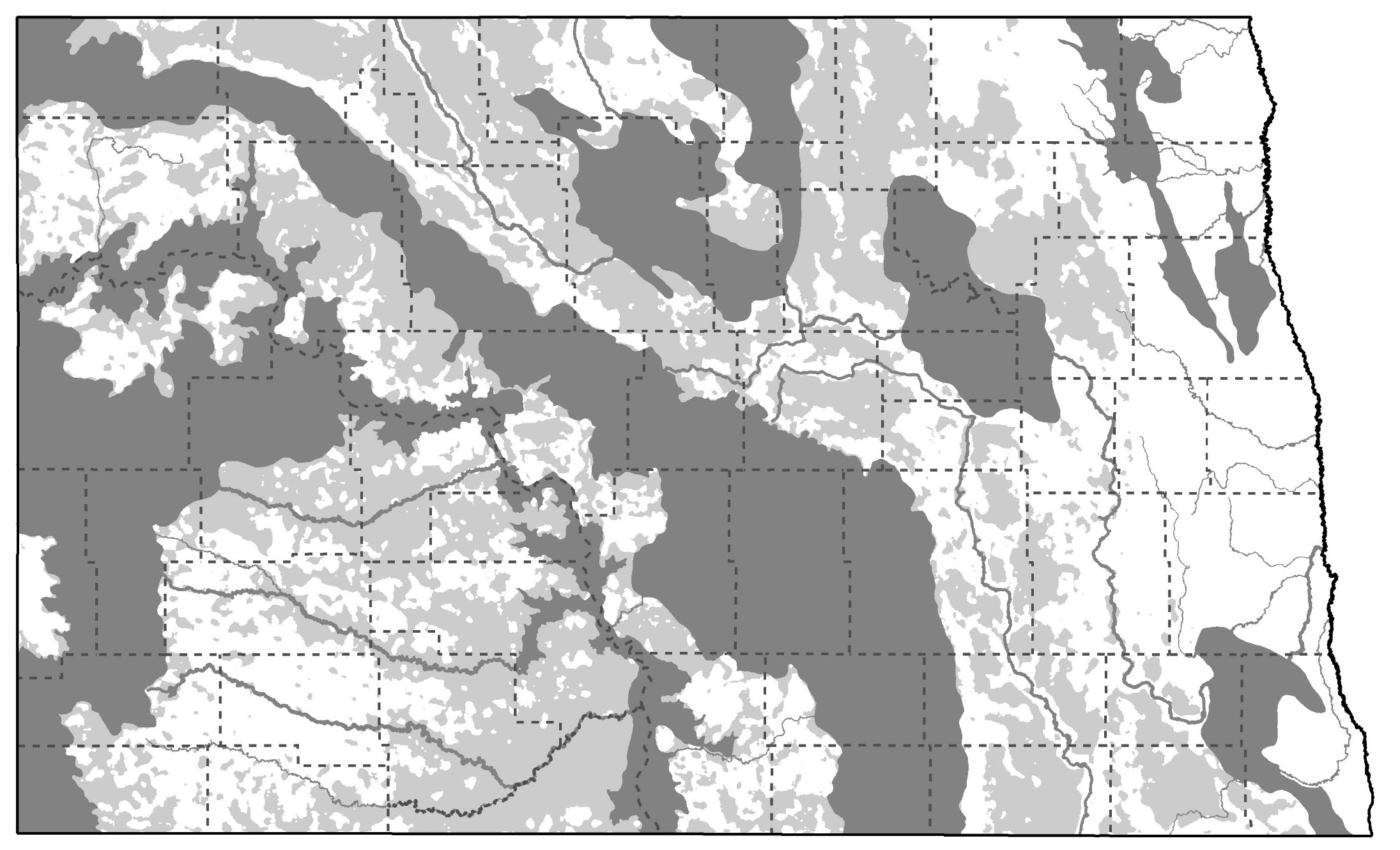
Figure 29. 2025 Key Native Wildlife and Habitat Areas. Dark gray = High; medium gray = Medium; white = Low.