
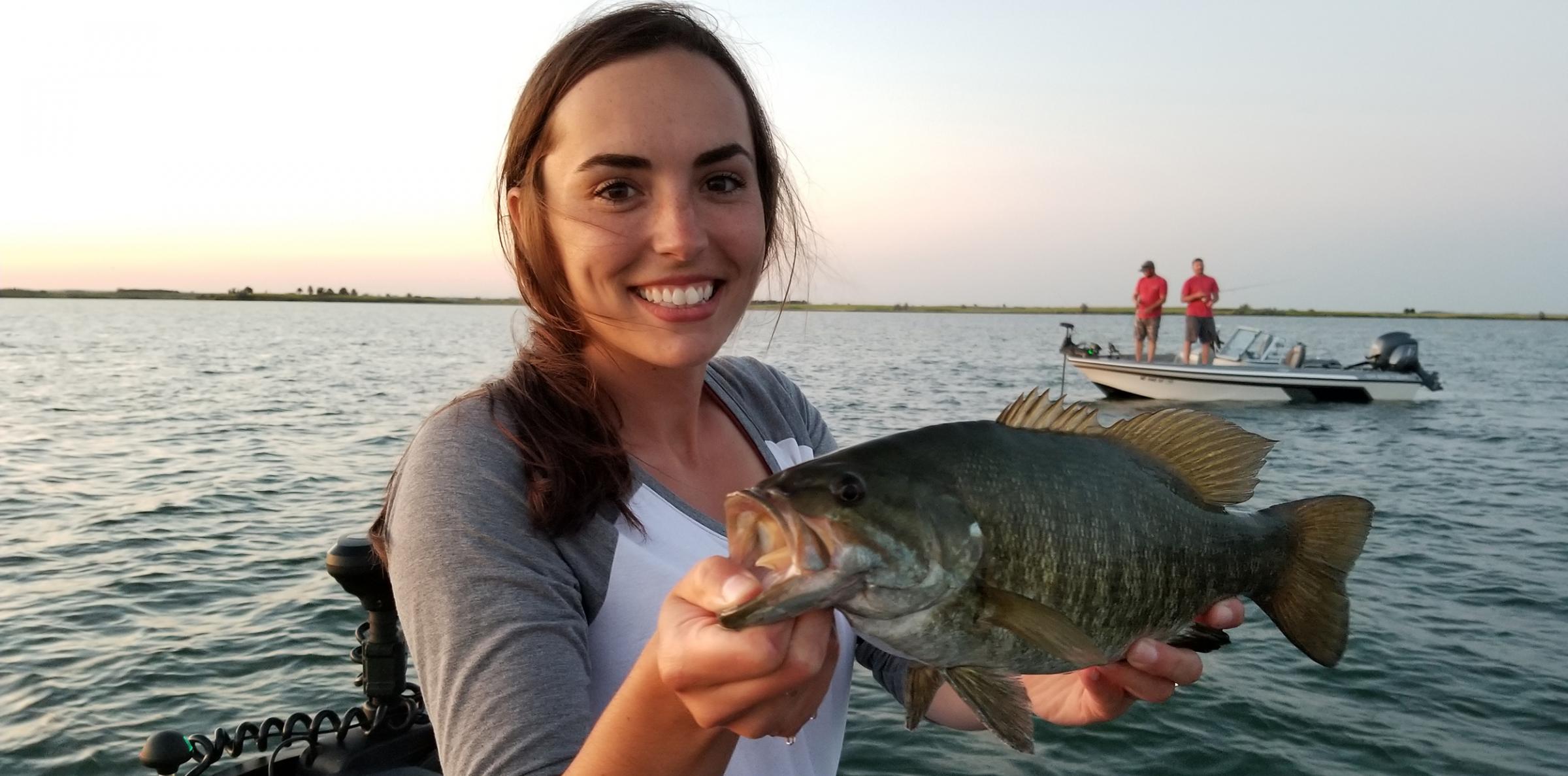
2020 North Dakota Fishing Waters
North Dakota has more than 400 fishing waters that have public access and some degree of management by state Game and Fish Department biologists.
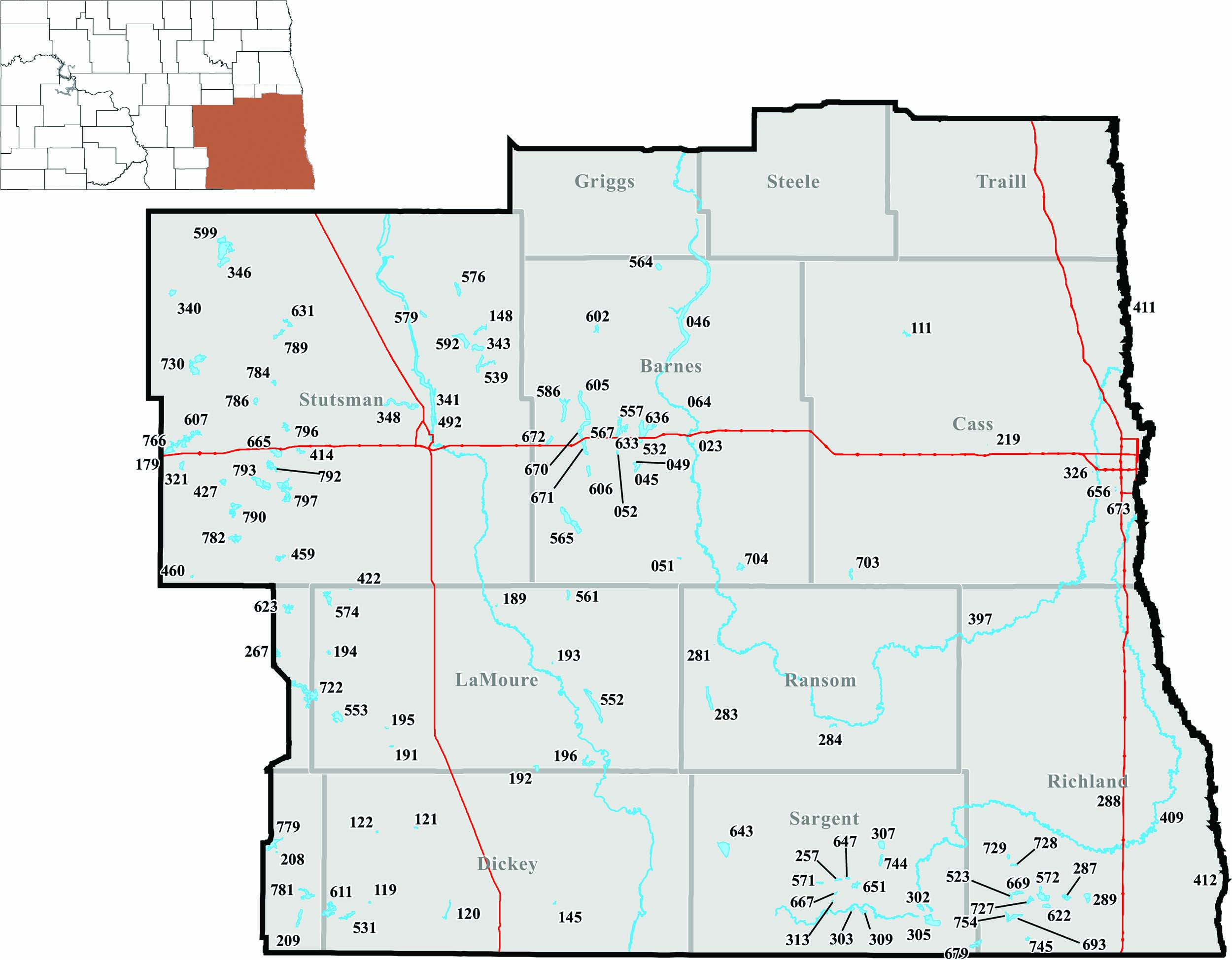
What follows are driving directions and infrastructure information for these managed waters, plus additional fish population remarks for many of them.
The number in parenthesis that follows each fishery is simply a code used by biologists to help identify those waters. The codes are also found on the accompanying maps to help readers locate specific waters.
The fishery outlooks provided by Game and Fish Department district fisheries supervisors and biologists are not all-inclusive reports, but rather peeks into each water’s fish populations to help frame angler expectations. With 400-plus lakes scattered across North Dakota, fisheries biologists have yet to conduct thorough population assessments on many of these waters.
Any changes and updates on managed lakes appear on the Game and Fish Department’s website.
Most state public fishing waters have boat ramps. Lakes or rivers where no ramp exists are listed as “no ramp.” Check signs at each area for further restrictions.
Click on a thumbnail to go directly to that district's report.
Devils Lake Basin | Missouri River System
FISHERIES BY DISTRICT
 Click for a larger image.
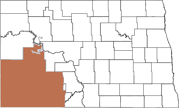
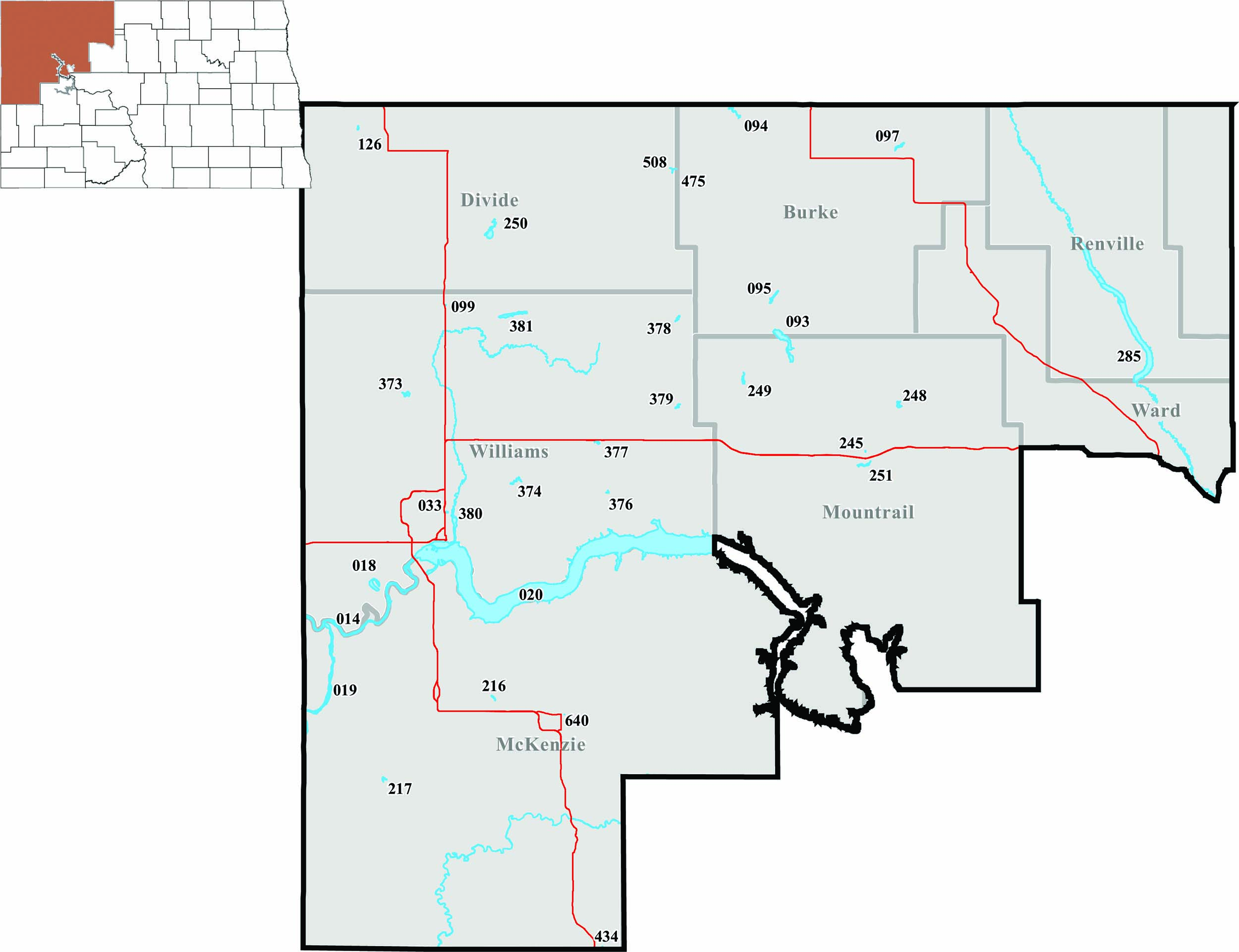
NORTHWEST FISHERIES DISTRICT
Aaron Slominski, district fisheries biologist, Williston
Burke County
- Northgate Dam (097) – 6 miles north, 1 mile west, 2 miles north, .5 miles west of Bowbells. Good walleye, bluegill and crappie populations. Stocked with rainbow trout annually, with some nice-sized carry-over trout. Decent largemouth bass population. (Fishing pier).
- Powers Lake (093) – Southeast side of Powers Lake. Primarily a northern pike fishery, with fish of various sizes. Suffered a partial winterkill in 2019. (Fishing pier).
- Short Creek Dam (094) – 5.5 miles north of Columbus. Significant winterkill in 2019 reduced fish populations. Stocked with adult perch, adult bluegill and fingerling walleye in spring 2019. (Fishing pier).
- Smishek Lake (095) – 4 miles northwest of Powers Lake. Decent numbers of walleye and northern pike, with some large fish of both species. Small yellow perch and bluegill abundant, with some large bluegill. White suckers fairly abundant and a management problem. (Fishing pier).
Divide County
- Baukol-Noonan Dam (475) – 2 miles east, .5 miles south of Noonan. Decent northern pike population. Walleye and largemouth bass present. Small yellow perch and bluegill abundant. (Fishing pier).
- Baukol-Noonan East Mine Pond (508) – 2 miles east, .5 miles south of Noonan. Good number of largemouth bass. Small bluegill and small yellow perch abundant. Black bullheads present.
- Magnuson’s Slough (250) – 12 miles north of Alamo on County Road 11. Decent number of smaller perch. (No ramp).
- Skjermo Lake (126) – 3 miles west, 4 miles northwest of Fortuna. Good perch population, with some nice fish. Northern pike and bluegill in low numbers. (Fishing pier).
Mckenzie County
- Arnegard Dam (216) – .5 miles west, 2 miles north, 1.5 miles west of Arnegard. Good number of northern pike. Yellow perch present, but most are smaller. Abundant black bullhead population. Stocked with adult catfish in 2019. (Fishing pier).
- Glovatsky Pond (434) – .5 miles east, .5 miles south, .5 miles east of the junction of U.S. Highway 85 and ND Highway 200. New pond. Bluegill stocked in 2019. Catchable-sized rainbow trout will be stocked annually, beginning in 2020. (No ramp).
- Sather Dam (217) – 11 miles south, 8 miles west of Alexander. Total winterkill in 2019. Stocked with adult bluegill in spring 2019. (Fishing pier).
- Watford City Park Pond (640) – Southeast side of Watford City. All fish lost to winterkill nearly every winter. Stocked annually in spring with adult channel catfish and catchable-sized rainbow trout. (Fishing pier, no ramp).
Mountrail County
- Clearwater Lake (248) – 2 miles east, 3.8 miles north, .5 miles east, 3 miles north-northeast, .5 miles east of Stanley. Decent number of 13- to 17-inch walleye, small northern pike abundant, yellow perch in low numbers.
- Stanley Pond (245) – Northeast side of Stanley. Significant winterkill most winters. Stocked annually in spring with adult channel catfish and catchable-sized rainbow trout. (Fishing pier).
- Stanley Reservoir (251) – 1 mile south of Stanley. Total winterkill in 2019. Stocked with fingerling northern pike in spring 2019.
- White Earth Dam (249) – 6 miles north, 8.5 miles east, 2 miles south of Tioga. Fair numbers of walleye and northern pike. Low numbers of yellow perch, black crappie and some large bluegill. White suckers fairly abundant and a management problem. (Fishing pier).
Renville County
- Lake Darling (285) – 16 miles north, 13 miles west of Minot. Strong northern pike, walleye and yellow perch populations, and a few smallmouth bass. Black bullheads abundant and a serious management problem. (Fishing pier).
Williams County
- Blacktail Dam (373) – 5 miles north, 5 miles west, 1 mile north of the junction of U.S. highways 2 and 85. Good numbers of walleye and northern pike, with some bigger fish. Small yellow perch and bluegill abundant, with some bigger bluegill in low numbers. Low number of smallmouth bass. White suckers are fairly abundant and remain a management concern. (Fishing pier).
- Cottonwood Lake (381) – 1 mile east, .5 miles north of Alamo. Total winterkill in 2019. Stocked with adult perch and walleye fingerlings in spring 2019. (Fishing pier).
- East Spring Lake Pond (380) – North side of Williston. Winterkills every year. Fishing opportunities reliant on annual stocking of adult northern pike. (Fishing pier, no ramp).
- Epping-Springbrook Dam (374) – 1.5 miles east of Springbrook. Fair northern pike and walleye populations. Small yellow perch abundant. Black bullheads and white suckers abundant and a serious management problem. (Fishing pier).
- Kettle Lake (099) – 3 miles east, 2.5 miles north of Zahl. Stocked annually with rainbow trout. Largemouth bass and bluegill present. (Fishing pier).
- Kota-Ray Dam (376) – 5 miles south, .5 miles east, 2 miles south of Ray. Good number of nice largemouth bass. Small yellow perch abundant. Walleye, bluegill and smallmouth bass present. Rainbow trout stocked annually. (Fishing pier).
- Little Muddy River (393) – East edge of Williston. Highly dependent on high water levels and fish movement from upper Missouri River. Fair populations of northern pike and channel catfish, with many other species present. (Fishing pier).
- McGregor Dam (378) – 1 mile south of McGregor. Total winterkill in 2019. Stocked with catchable-sized rainbow trout, adult bluegill and adult crappie in spring 2019. (Fishing pier).
- McLeod (Ray) Reservoir (377) – Southwest side of Ray. Northern pike abundant. Walleye, yellow perch and bluegill in low numbers. (Fishing pier).
- Tioga Dam (379) – North side of Tioga. Northern pike abundant. Stocked with adult perch and adult bluegill in 2019. (Fishing pier).
- Trenton Lake (018) – South side of Trenton. Good crappie population. Decent numbers of walleye, northern pike and catfish. Due to periodic interconnection with the Missouri River, many other species present. (Fishing pier).
- West Spring Lake Pond (033) – North edge of Williston. Stocked annually with rainbow trout and adult catfish. Black bullheads abundant and a serious management problem. (No ramp).
Rivers and Lakes
- Upper Missouri River (014) – Missouri River from Williston to Montana state line. Primarily a spring and fall fishery for sauger and walleye. Abundant channel catfish. Many other species present.
- Yellowstone River (019) – Near the towns of Buford, Cartwright and Fairview. Primarily a spring and fall fishery for sauger and walleye. Channel catfish abundant. Many other species present. (Fishing pier).
 Click for a larger image.
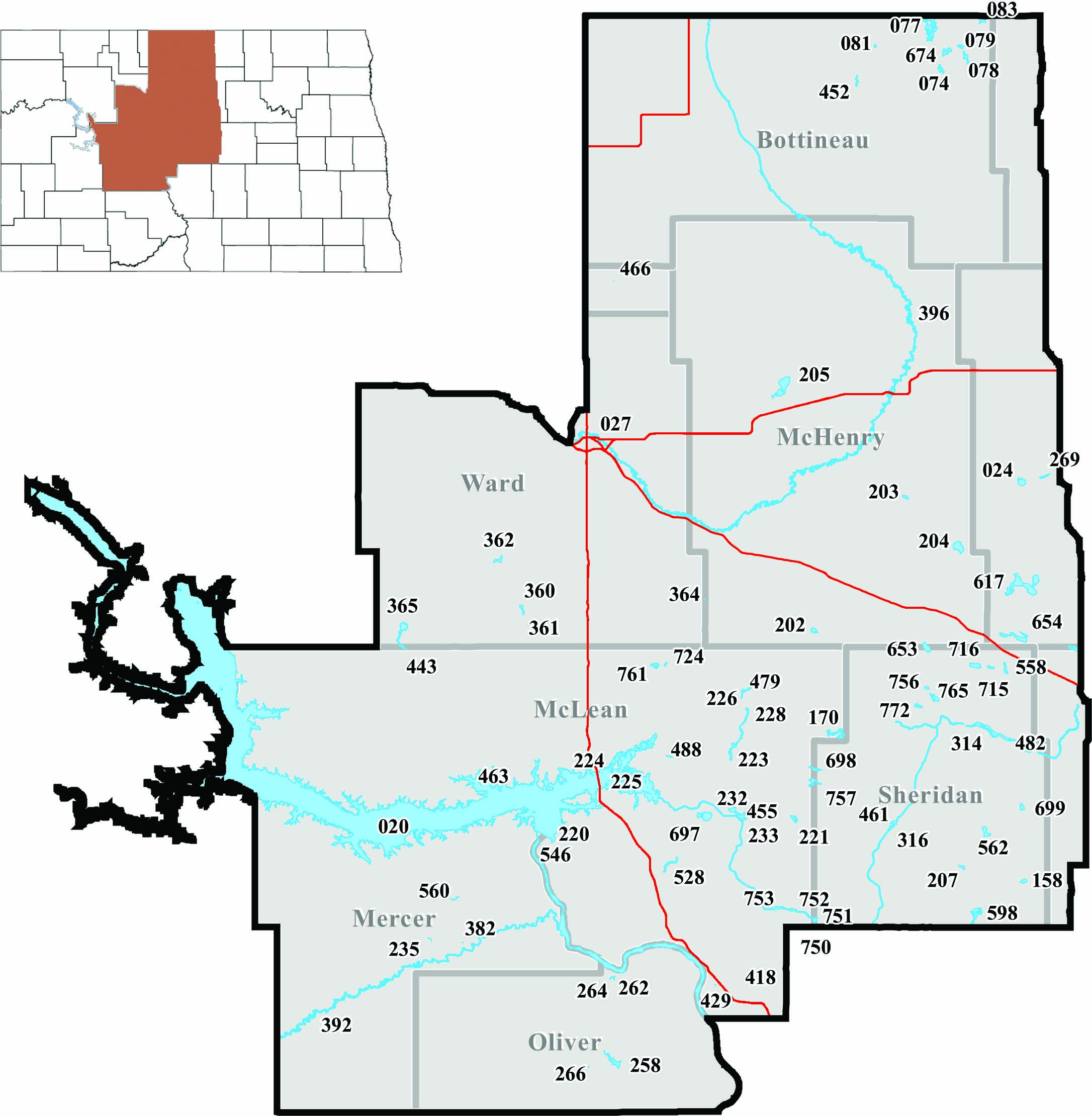
NORTH CENTRAL FISHERIES DISTRICT
Jason Lee, district fisheries supervisor, Riverdale
Bottineau County
- Boundary Lake (083) – 9 miles north, 11 miles east, 2.5 miles north of Bottineau. Decent number of 6- to 8-inch perch. (No ramp).
- Carbury Dam (452) – 1 mile south, 1 mile west of Carbury. Recent fish kills have led to low pike and perch numbers. (Fishing pier).
- Lake Metigoshe (077) – 9 miles north, 4 miles east, 1 mile north of Bottineau. Several sizes of bluegill, including some large fish, along with some nice crappie. Good number of walleye in a wide range of sizes. Good pike fishing, with some large fish. (Fishing pier).
- Long Lake (078) – 8 miles north, 7 miles east, 1 mile south, 1 mile east, .5 miles south, .3 miles east of Bottineau. Decent pike and walleye populations. Lots of small perch and some nice bluegill.
- Loon Lake (674) – 9 miles north, 4 miles east, 2 miles south, 2 miles east, .5 miles north of Bottineau. High number of mostly smaller perch. Good number of decent-sized walleye. (No ramp).
- Pelican Lake (079) – 9 miles north, 8 miles east, .5 miles southwest of Bottineau. Decent number of northern pike.
- Strawberry Lake (081) – 4 miles north, 2.5 miles east, .5 miles south of Carbury. Rainbow trout stocked annually. Some larger trout. (Fishing pier).
- Thompson Lake (074) – 9 miles north, 4 miles east, 2 miles south, 1 mile east, 1 mile south of Bottineau. Mostly smaller yellow perch abundant. (No ramp).
Burleigh County
- New Johns Lake (750) – 11.8 miles south, 3 miles east of Mercer. Decent walleye numbers, with some larger fish. Pike population increased in recent years. Good number and sizes of smallmouth bass. Periodically stocked with muskies. (Fishing pier).
Mchenry County
- Buffalo Lodge Lake (205) – 2 miles east, 3 miles north, 2 miles east of Granville. Good numbers of northern pike and walleye. (Fishing pier).
- Cottonwood Lake (202) – 2.5 miles north of Butte. Decent number of pike and a good number of 14- to 26-inch walleye. (Fishing pier).
- George Lake (203) – 13 miles north, 1 mile east, 1.3 miles north, .5 miles east of the junction of U.S. Highway 52 and ND Highway 14. Good number of pike, with some large fish. (Fishing pier).
- Round Lake (204) – 6 miles north, 3.7 miles east, 1 mile north of Drake. Good numbers of pike and walleye. (No ramp).
Mclean County
- Brush Lake (221) – 3 miles north of Mercer. Good numbers of walleye and smaller perch. Good pike population, with some larger fish. (Fishing pier).
- Camp Lake (479) – 17.5 miles north, 2 miles east of Turtle Lake. Decent number of pike and lots of small perch. (No ramp).
- Camp Loop Pond (546) – 3 miles southwest of Riverdale on U.S. Army Corps of Engineers’ downstream campground. Rainbow trout stocked annually. (Fishing pier, no ramp).
- Coal Lake (528) – 3 miles south, 1.5 miles east, .75 miles north of Underwood. Severe winterkill in 2018-19. Restocked with walleye fingerlings in 2019. (No ramp).
- Crooked Lake (223) – 10 miles north, .2 miles east, .1 mile south of Turtle Lake. High number of 18- to 32-inch pike, some walleye, and mostly smaller perch. (Fishing pier).
- Custer Mine (224) – 4 miles east, 2 miles south of Garrison. A good put-and-take rainbow trout fishery in a small, easy-to-fish pond.
- East Park Lake (752) – 9 miles south of Mercer. Decent walleye numbers, with some larger fish. Fair number of northern pike. (Fishing pier).
- Lake Audubon (225) – North of Coleharbor. Good number of walleye and an excellent smallmouth bass fishery. Anglers should see good numbers of 14- to 20-inch walleye. Some large pike. (Fishing pier).
- Lake Brekken (232) – 1.5 miles north of Turtle Lake. Good number of walleye, with some larger fish. Mostly smaller perch abundant. (Fishing pier).
- Lake Gertie (724) – 1 mile south of Benedict. Good number of 22- to 29-inch northern pike. (No ramp).
- Lake Holmes (455) – 1 mile northeast of Turtle Lake. Good number of walleye, with some larger fish. Small perch abundant.
- Lightning Lake (233) – .5 miles east of Turtle Lake. A quality trout fishery, with some large fish. Stocked annually with rainbow trout. (Fishing pier).
- Long Lake (228) – 13 miles north, 4 miles east, 2 miles north, 1.5 miles west of Turtle Lake. Good number of 19- to 32-inch northern pike.
- Painted Woods Creek (418) – 5 miles southeast of Washburn. Fair number of northern pike. (No ramp).
- Painted Woods Pond (429) – .6 miles south, .25 miles west of the junction of U.S. Highway 83 and ND Highway 1804. Stocked annually with rainbow trout. First stocked with bluegill in 2018. (No ramp).
- Pelican Lake (757) – 7 miles north, 3 miles east, .4 miles north of Mercer. Good numbers of pike and smaller perch. (No ramp).
- Riverdale City Pond (220) – North side of Riverdale. Popular pond for kids and family outings. Lots of small bluegill and bass. (Fishing pier, no ramp).
- Schroeder East (170) – 14 miles north, 3.7 miles east of Mercer. Newer perch lake, with some decent-sized fish. (No ramp).
- Scooby Lake (761) – .5 miles south, 1 mile west, .3 miles south of Benedict. Newer fishery, with a good number of 14- to 18-inch walleye. Some good-sized perch. (No ramp).
- Strawberry Lake (226) – 17.5 miles north, 2 miles east of Turtle Lake. Good pike and walleye populations. Lots of small perch and bluegill.
- Triangle Y Pond (463) – 4 miles west, 1.5 miles south, 1 mile west, 1 mile south, 1 mile west, .5 miles south of Garrison. Small pond stocked with perch, used mostly by Triangle Y kids. (Fishing pier, no ramp).
- Turtle Lake (697) – 4.5 miles west, 1 mile north of Turtle Lake. Decent number of northern pike, with some larger fish. (No ramp).
- Weishaar WPA (488) – 8 miles north, 8 miles west, 1 mile north of Turtle Lake. Winter perch fishery for mostly smaller perch. (No ramp).
- West Park Lake (753) – 9 miles south, 3 miles west of Mercer. Fair numbers of walleye and small perch. Good number of pike, with some larger fish. (No ramp).
Mercer County
- Beulah Mine Pond (235) – 2 miles north, 2.5 miles east, .5 miles north of Beulah. Some pike and perch. (No ramp).
- Harmony Lake (560) – 6 miles north, 1 mile west of Hazen. Fair number of bluegill, with some quality-sized fish. (Fishing pier).
- Hazen Creek (382) – West end of Hazen. Rainbow trout stocked annually in spring. (No ramp).
Oliver County
- East Arroda Dam (262) – 1 mile east of Fort Clark ND Highway 200A. Pike and perch numbers increased in recent years, with mostly smaller fish. Earthen fishing piers available for shore-fishing access.
- Nelson Lake (258) – 5 miles east, 3 miles south of Center. Best largemouth bass lake in the state. Open water year-round allows warmwater fish to grow better than in other lakes. Quality-sized bluegill and crappie abundant. (Fishing pier).
- Oliver County Sportsmen’s Pond (266) – 4 miles south, .5 miles west of Center. Rainbow trout stocked annually. (No ramp).
- West Arroda Dam (264) – 1 mile east of Fort Clark ND Highway 200A. Stocked with adult bluegill, crappie and rainbow trout in spring 2019. Earthen fishing piers available for shore-fishing access.
Pierce County
- Antelope Lake (617) – 6.7 miles north, 3 miles east, 1 mile north, 2 miles east, 2 miles south of Anamoose. Nice-sized perch abundant. Good number of walleye from 16-26 inches.
- Balta Dam (269) – .5 miles south of Balta. Recent winterkill reduced northern pike population.
- Clear Lake (654) – 6 miles east, .7 miles south of Anamoose. Good number of quality-sized walleye from 14-27 inches. (No ramp).
- Davis Lake (024) – 2 miles west, 1.5 miles south of Balta. Good number of small northern pike.
Renville County
- Glenburn Pond (466) – North side of Glenburn. Small pond stocked annually with trout. Perch and bluegill stocked periodically. (No ramp).
Sheridan County
- Barreth Lake (158) – 2 miles south, 2 miles east, 2 miles south, .6 miles west of Goodrich. Newer perch lake, with some keeper-sized fish. (No ramp).
- Bender Lake (715) – .5 miles south, 4 miles west, .5 miles south of Martin. Fair number of mostly small perch. (No ramp).
- Cherry Lake (698) – 7 miles north, 3 miles east, 2 miles north, .3 miles west of Mercer. Fair number of small perch. (No ramp).
- Coal Mine Lake (482) – 14 miles south, 5 miles east of Anamoose. Significant winterkill greatly reduced northern pike numbers. (Fishing pier).
- Davis WPA (598) – 8 miles south, 1 mile east of Denhoff. Decent number of walleye, with some larger fish. Mostly smaller-sized perch. (No ramp).
- Doctor Lake (207) – 2 miles south of Denhoff. Newer perch lake, with some keeper-sized fish. (No ramp).
- Heckers Lake (751) – 9 miles south, 2.4 miles east of Mercer. Fair number of walleye, with some quality-sized fish. Decent numbers of pike and smallmouth bass. (No ramp).
- Hinsz Lake (765) – 8 miles south, 3 miles west, 1 mile south, .6 miles west, .7 miles northwest of Anamoose. Good number of 14- to 21-inch walleye.
- Kaibel Lake (756) – 10.2 miles south of Drake. Lots of perch, but many are smaller-sized. (No ramp).
- Lake Richard (653) – 4.5 miles south of Drake. Good number of 14- to 27-inch walleye. (No ramp).
- Miller Lake (772) – 18 miles north, 2 miles east, .2 miles south of McClusky. Newish perch lake. (No ramp).
- Mud Lake (716) – 4.5 miles south of Anamoose. Newer perch lake, with a fair number of fish. (No ramp).
- North (Hoffer) McClusky (461) – 2 miles north, 1 mile west of McClusky. Recent fish kills greatly reduced northern pike numbers. (No ramp).
- Sheyenne Lake (314) – 13.5 miles south, 1.5 miles east, .4 miles north of Anamoose. Pike stocked periodically. (No ramp).
- South (Hoffer) McClusky (316) – 2 miles north, 1 mile west of McClusky. Decent numbers of perch, walleye and pike. Some bluegill and crappie. (Fishing pier).
- Stober Lake (562) – 9 miles east, 2 miles north, 2 miles east of McClusky. Fair numbers of walleye and perch, with some larger fish.
- Vollrath Lake (699) – 5.5 miles north, 1 mile east, 1 mile south of Goodrich. Good number of perch, with some quality-sized fish. (No ramp).
- Wolf Lake (558) – .5 miles south, 1.8 miles west of Martin. Restocked with pike fingerlings in spring 2018. (No ramp).
Ward County
- Hiddenwood Lake (443) – 8 miles south of Makoti. Decent numbers of yellow perch, walleye, smallmouth bass and pike. (Fishing pier).
- Makoti Lake (365) – 6 miles south of Makoti. High number of 24- to 34-inch northern pike. (No ramp).
- North Carlson Lake (360) – 10 miles east of Ryder. Good number of northern pike and mostly small perch.
- Rice Lake (362) – 4 miles north, 7 miles east, 2 miles north of Ryder. Pike abundant, ranging from 18-37 inches. (Fishing pier).
- South Carlson Lake (361) – 10 miles east of Ryder. Fair number of mostly smaller pike. Bluegill numbers increasing. (Fishing pier).
- State Fair Pond (027) – North end of state fair grounds. Small pond stocked annually with trout and panfish. (Fishing pier, no ramp).
- Velva Sportsmen’s Pond (364) – 7 miles south, 1.5 miles west, 1 mile south, .5 miles west of Velva. Consistently a quality fishery for nice-sized rainbow and brown trout.
Rivers and Lakes
- Knife River (392) – In Dunn and Mercer counties. Connected to the Missouri River, so a variety of fish species available. (No ramp).
- Souris River (Mouse River) (396) – North central part of state. Good numbers of pike, walleye and perch. (Fishing pier).
- McClusky Canal (464) – Central part of state in McLean, Burleigh and Sheridan counties. Excellent smallmouth bass fishery, with some larger fish. Variety of fish species available. (No ramp).
 Click for a larger image.
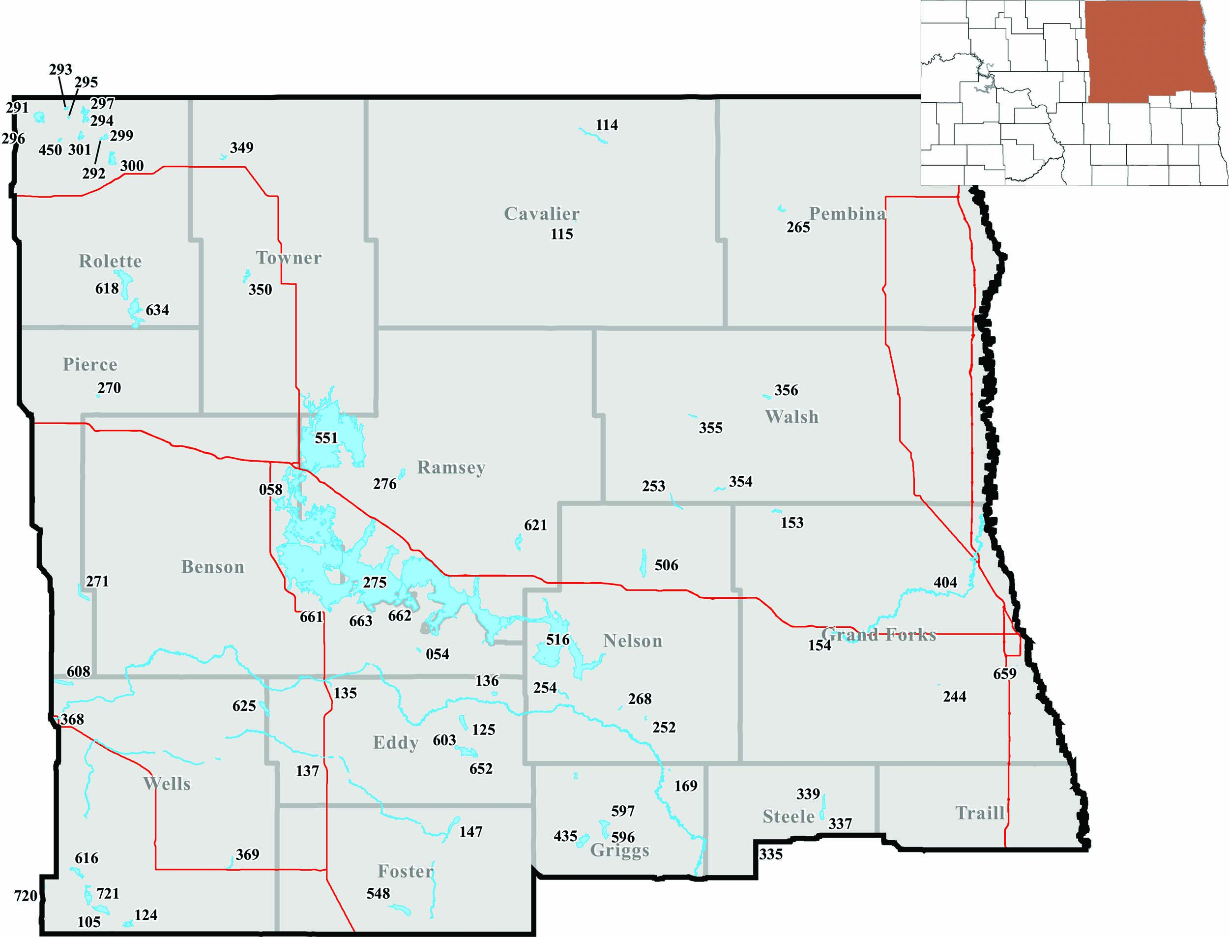
NORTHEAST FISHERIES DISTRICT
Randy Hiltner, district fisheries supervisor, Devils Lake
Benson County
- Fort Totten Dam (663) – .5 miles east of Fort Totten. No recent information. Managed by the U.S. Fish and Wildlife Service. (No ramp).
- Gravel Pit Lake (661) – 4.5 miles west of Fort Totten. No recent information. Managed by the U.S. Fish and Wildlife Service. (No ramp).
- Mission Lake (662) – 5 miles south, 1.5 miles east, 2 miles south of Devils Lake. No recent information. Lake managed by the U.S. Fish and Wildlife Service. (No ramp).
- Wood Lake (054) – 2 miles west, 1 mile south of Tokio. Bluegill numerous, but most are about 7 inches. Decent number of walleye and pike.
Cavalier County
- Langdon City Pond (115) – South side of Langdon. Put-and-take trout lake, with most fish caught in May. (Fishing pier).
- Mount Carmel Dam (114) – 9 miles north, 2 miles east, 2 miles north of Langdon. Fair number of perch, with most under 8 inches. Walleye numbers fair, with several sizes available, including some big fish. Decent number of nice-sized pike. Increasing crappie numbers, with most under 9 inches. (Fishing pier).
Eddy County
- Adams Lake (603) – 10 miles south of Warwick. Lots of smaller perch around 7 inches, with some up to 10 inches, and a few walleye. (No ramp).
- Lake Coe (652) – 10 miles south of Warwick on east side of Eddy County Road 8. Good number of walleye, with several size classes. Fish longer than 18 inches common.
- New Rockford Reservoir (137) – North side of New Rockford. Winterkilled in 2019, but adult northern pike were stocked in spring for an instant fishery. (Fishing pier, no ramp).
- North Lake Washington (125) – 6 miles south of Warwick. Good walleye population, with fish up to 21 inches. Some keeper-sized perch, but most still too small.
- Warsing Dam (135) – 1 mile northeast of Sheyenne. Partial winterkill in 2019. Spring netting survey sampled pike, perch and bullheads. Northern pike adults were stocked in spring 2019 to establish an instant fishery. (Fishing pier).
Foster County
- Dry Lake (548) – 7 miles east, 5 miles south, 2 miles east of Carrington. Fair number of walleye, with most fish about 18 inches. Low perch numbers. (No ramp).
Grand Forks County
- English Coulee Pond (244) – 5 miles south, 3 miles east, 1 mile south, .5 miles east of Emerado. No recent information. (No ramp).
- Fordville Dam (153) – 5 miles west, 1 mile north, .5 miles west, .5 miles north of Inkster. Fair numbers of eating-sized walleye and larger pike, with a fair number of perch under 10 inches. Bluegill numbers increasing, with fish up to 8 inches. Bullheads and suckers remain a management issue. (Fishing pier).
- Kolding Dam (155) – 5 miles southeast, 1 mile south of Niagara on U.S. Highway 2. Adult pike stocked following winterkill in 2018-19.
- Larimore Dam (154) – 2 miles northeast of Larimore. Walleye, pike, largemouth bass, perch, crappie and bluegill provide angling opportunities. Various sizes of walleye and pike, with some bigger fish. Crappie and bluegill are smaller, but also some nice fish. Most perch less than 9 inches. (Fishing pier).
- Niagara Dam (156) – North of Niagara. Probable winterkill in 2019, but adult pike were stocked in spring.
- Ryan Park Pond (659) – South side of Grand Forks. Small urban fishery that is a good place to take a kid fishing and is stocked annually with trout. Bluegill also introduced. (Fishing pier, no ramp).
Griggs County
- Carlson-Tande Dam (169) – 1 mile south, 5 miles west of Aneta. 2019 netting survey showed small perch, bluegill and pumpkinseeds, along with a few nice walleye and pike.
- Lake Addie (596) – 4 miles east, 1 mile south, 1 mile west of Binford. Managed as a walleye and perch fishery. Several sizes of walleye available. Most perch smaller. (No ramp).
- Lake Jessie (597) – 4 miles east, 1 mile south, 1 mile west of Binford. Primarily an ice fishing lake for pike that average about 28 inches. A few perch that may reach 9 inches. (No ramp).
- Red Willow Lake (168) – 6 miles north, 2 miles west of Binford. Walleye, pike, perch and bluegill common. Nice walleye around 20 inches available. Pike abundant and in many sizes. Bluegill common and mostly smaller, but some up to 11 inches. Perch typically small.
- Sibley Lake (435) – 1 mile west, 3 miles south of Binford. Good pike population, with fish averaging about 5 pounds. Some perch available. (No ramp).
Nelson County
- Lake Laretta (506) – 2 miles west, 2 miles north of Michigan. Fair number of medium-sized pike. Perch that survive predation are large, but uncommon. Good number of walleye over 20 inches. (No ramp).
- McVille Dam (252) – 1 mile east of McVille. Some larger walleye and pike, but at low densities. Perch and bluegill abundant, but most typically less than 8 inches. (Fishing pier).
- Silver Creek Dam (268) – 4 miles west, .5 miles south of McVille. Small reservoir with a winter pike fishery. Perch present, but usually less than 9 inches. Bullheads and suckers abundant and a management problem. (No ramp).
- Tolna Dam (254) – 1 mile south, 2 miles east of Tolna. Fair walleye and pike densities, several sizes present, with some big fish. Perch numbers fairly low. Some smallmouth bass.
- Whitman Dam (253) – 1.5 miles north, 3 miles east of Whitman. Keeper-sized perch, with most fish under 10 inches. Fair fishing for pike and walleye. Crappie population is good, with some larger fish. (Fishing pier).
Pembina County
- Renwick Dam (265) – 6 miles west, 1 mile north of Cavalier. Mostly pike for a predator fish. Perch and crappie abundant, with most under 8 inches. White suckers and bullheads abundant and a management problem. (Fishing pier).
Pierce County
- Sand Lake (270) – 4 miles north of Pleasant Lake. Good pike fishery, with fish commonly up to 5 pounds. Perch numbers good, but most fish less than 8 inches.
Ramsey County
- Cavanaugh Lake (276) – 9 miles north, 1 mile west, .5 miles north of Devils Lake. Winterkills often, but fish repopulate during high spring runoff. No game fish sampled in 2019 netting survey. (No ramp).
- Fenster Lake (621) – 3 miles north, 4 miles east of Crary. Pike in fair numbers, with most fish more than 5 pounds. Low density perch population. (No ramp).
Rolette County
- Belcourt Lake (300) – 2 miles north of Belcourt. Yellow perch and northern pike abundant, with some larger keeper-sized fish. Black bullheads abundant.
- Cain Lake (450) – 2 miles south, 9 miles west, .5 miles north of St. John. No recent information. Managed by the U.S. Fish and Wildlife Service. (No ramp).
- Carpenter Lake (291) – 12 miles west of St. John. Good pike population, with most fish longer than 25 inches. Recently stocked walleye are about 15 inches. A few perch, but most are under 8 inches.
- Dion Lake (293) – 10 miles west, 2 miles north, 1 mile east of St. John. Walleye densities lower than recent years, but there are fish up to 20 inches. Perch numbers are decent, with most fish under 10 inches. Illegally stocked pike common, with some fish longer than 30 inches. (Fishing pier).
- Gordon Lake (299) – 4.5 miles north, 1 mile west, .25 miles northwest of Belcourt. Walleye and yellow perch abundant, with some larger fish. Northern pike and bluegill in good numbers.
- Gravel Lake (294) – 6 miles west, .5 miles north of St. John. Pike, bluegill and perch fishery. Pike average about 24 inches, with some up to 36 inches. Most perch under 10 inches. Bluegill mostly under 7 inches. (Fishing pier).
- Hooker Lake (295) – 8 miles west of St. John. One of a few rainbow trout lakes in the district. Trout stocked annually and reach maximum size in fall. Some older, larger trout available. (Fishing pier).
- Island Lake (634) – 3 miles west, 2 miles south of Mylo. Partial winterkill in 2018-19, yet there are still good numbers of 24-inch–plus pike.
- Jarvis Lake (301) – .75 miles southwest, 6 miles west of St. John. Yellow perch abundant, with a few larger fish. Walleye ranging from 12-18 inches abundant. Bluegill and northern pike present. (No ramp).
- Long Lake (618) – 2 miles south, 5.3 miles east of Rolette. Good number of pike, with the average fish more than 5 pounds. (No ramp).
- Upsilon Lake (297) – 6 miles west, 1 mile north of St. John. Partial winterkill in 2019. Annual netting survey in June 2019 sampled good pike numbers of all sizes and some large fish. Some nice walleye sampled, along with many smaller bluegill and some smaller perch. Larger perch and bluegill at low densities. (Fishing pier).
- Wheaton Lake (292) – 4.5 miles north, 2 miles west of Belcourt. Northern pike and yellow perch fishery, with some decent keeper-sized fish.
Steele County
- Finley Dam (Lynch Lake) (335) – 1 mile south of Finley. Pike stocked regularly and provide fishing opportunities. Most pike around 20-26 inches. High bullhead population and stunted perch are management problems. (No ramp).
- North Golden Lake (339) – 10 miles east, 4 miles north, .5 miles west of Finley. Perch numbers down, with most fish less than 10 inches. Fair numbers of keeper-sized pike and walleye. Walleye longer than 20 inches and pike up to 10 pounds. Low number of bluegill, but decent-sized. Bullheads a serious fish management problem.
- South Golden Lake (337) – 10 miles east, 3 miles north, .5 miles west of Finley. Primarily a walleye and perch fishery, with some pike and bluegill. Walleye do get large, with fish up to 8 pounds. Fair number of 20-inch-plus fish. Perch numbers relatively low. Pike numbers low, but bigger fish available. Some nice bluegill. Bullheads abundant and a management problem. (Fishing pier).
Towner County
- Armourdale Dam (349) – 9 miles east, 1.5 miles north of Rolla. Netting survey in 2019 showed walleye up to 16 inches, with most being smaller. Nice pike from 18-36 inches. Perch up to about 9 inches. (Fishing pier).
- Bisbee Dam-Big Coulee (350) – 1 mile east of Bisbee. Pike, walleye, perch, bluegill and crappie. Most walleye over 16 inches. Good pike numbers, with some fish up to about 6 pounds. Most perch are 8-9 inches. Also, the occasional large bluegill and crappie. (Fishing pier).
Walsh County
- Bylin Dam (355) – 3 miles east, 3 miles south of Adams. Nice population of pike, with some keeper-sized walleye. Perch mostly smaller. (Fishing pier).
- Homme Dam (356) – 2 miles west of Park River. High perch numbers, with many in the 8- to 10-inch range. Crappie abundant, with most 6-9 inches, along with some bigger fish. Lower densities of pike and walleye. White suckers and bullheads abundant and problematic. (Fishing pier).
Wells County
- Georgeson Lake (625) – 3 miles north, 3 miles east, .25 miles north of Bremen. Perch population is mostly fish less than 8 inches. Few larger perch remain. (No ramp).
- Goose Lake (608) – 3 miles north, 3 miles east, 1 mile north of Harvey. Fair number of pike, with increasing size structure. Walleye population in fine shape, with a good number of fish longer than 17 inches. Nice perch, but low numbers and not common.
- Hurdsfield-Tuffy Lake (616) – 3.5 miles east of Hurdsfield. Lots of eating-sized walleye, ranging from 15-20 inches, with some big fish. Perch numbers fair, with most less than 11 inches. Carp are reproducing and may become a management problem. (No ramp).
- Silver Lake (105) – 1 mile west, 7.5 miles south, 2 miles west, 2 miles north of Bowdon. No recent information. (No ramp).
- Silver Lake WMA (721) – 3 miles south of Chaseley. Fair number of 9- to 12-inch perch, with the occasional jumbo. Fast-growing walleye around 15-20 inches. (No ramp).
- Sykeston Dam (369) – Northwest side of Sykeston. There were low oxygen levels in winter 2019, but a spring netting survey revealed pike, perch and bullheads. (Fishing pier).
Rivers and Lakes
- Turtle River (404) – In Grand Forks County. Rainbow trout stocked twice in spring and once in fall to provide a unique riverine trout fishery. Mostly a put-and-take fishery. (No ramp).
 Click for a larger image.
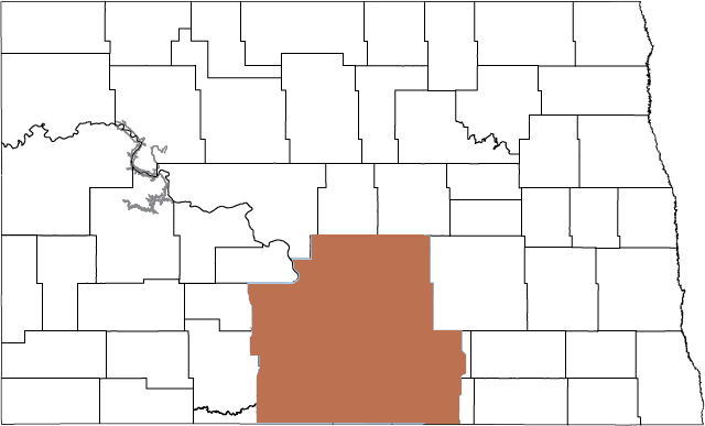
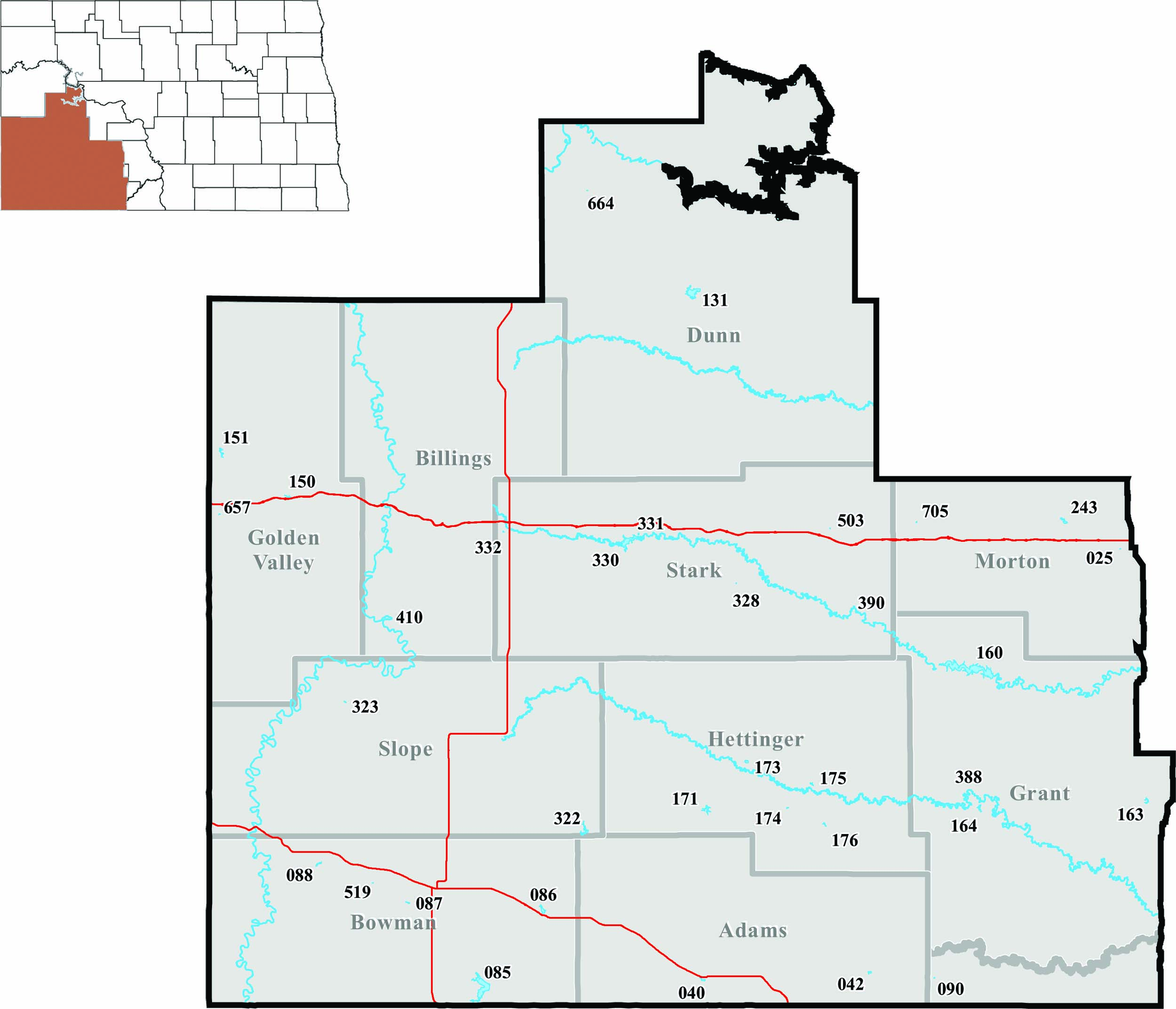
SOUTHWEST FISHERIES DISTRICT
Jeff Hendrickson, district fisheries supervisor, Dickinson
Adams County
- Mirror Lake (040) – South side of Hettinger. Bullheads up to a half-pound abundant. Some northern pike up to 8 pounds. Good number of channel catfish up to 5 pounds. (Fishing pier).
- North Lemmon (042) – 5 miles north of Lemmon, South Dakota. Rainbow trout stocked annually. Some brown trout up to 2 pounds. Small yellow perch abundant. Fair number of bluegill, with some up to three-quarters of a pound. Fair number of largemouth bass, mostly 1-4 pounds. Good number of walleye, mostly 3-10 pounds. (Fishing pier).
Bowman County
- Bowman-Haley Dam (085) – 11 miles south, 8 miles east, 2 miles south of Bowman. Some walleye up to 5 pounds, northern pike up to 16 pounds. Good number of white bass up to 1 pound and smallmouth bass up to 2 pounds. Some yellow perch and crappie up to a half-pound. Carp up to 15 pounds abundant, good for bowfishing. (Fishing pier).
- Gascoyne Lake (086) – 1.5 miles northwest of Gascoyne. Northern pike stocked annually, with some fish up to 2 pounds. Some carp up to 4 pounds. Bullheads and green sunfish abundant at times.
- Kalina Dam (087) – 2 miles west, 1 mile south, 1 mile west, 1 mile south of Bowman. Good number of pike up to 7 pounds. Some small bluegill, crappie and yellow perch. Make sure to access lake from south shore. (No ramp).
- Lutz Dam (519) – 2.5 miles south, 2 miles west, .75 miles north of Griffin. Rainbow trout stocked annually. Abundant small bluegill, some yellow perch and black crappie. (No ramp).
- Spring Lake (088) – 1 mile south, 4 miles west of Rhame. Good number of walleye up to 2 pounds, some perch up to three-quarters of a pound and small bluegill abundant.
Dunn County
- BarZ Dam (664) – 8 miles north, 3 miles west, 2 miles north, 3 miles northwest of Killdeer. Adult bluegill stocked in 2017. (No ramp).
- Lake Ilo (131) – 1 mile west, 1 mile south of Dunn Center. Pike up to 10 pounds abundant, some perch up to a half-pound. (Fishing pier).
Golden Valley County
- Beach City Pond (657) – Southwest side of Beach. Rainbow trout stocked annually. (Fishing pier, no ramp).
- Camels Hump Lake (150) – Northeast of Sentinel Butte I-94 Exit 10. Rainbow trout stocked annually, with fish up to 2 pounds. Largemouth bass mostly 1 pound abundant, with some up to 6 pounds. Fair number of bluegill up to three-quarters of a pound. Some brown trout and smallmouth bass.
- Odland Dam (151) – 7 miles north of Beach. Perch up to three-quarters of a pound abundant, some bluegill up to three-quarters of a pound and walleye up to 2 pounds. (Fishing pier).
Grant County
- Heart Butte Reservoir (160) – 15 miles south of Glen Ullin. Abundance of mostly small walleye, with some fish up to 6 pounds, catfish up to 10 pounds, pike up to 17 pounds, white bass up to 2 pounds, crappie up to 1 pound and smallmouth bass up to 3 pounds. Good number of perch up to 1 pound and some bluegill up to a half-pound. Abundant large buffalo up to 40 pounds and bullheads up to 1.5 pounds, some large carp up to 15 pounds. (Fishing pier).
- Raleigh Reservoir (163) – 3.5 miles west, .25 miles south of Raleigh. Small bluegill abundant, with some up to a half-pound, good number of walleye up to 3 pounds and some small yellow perch. Adult largemouth bass stocked in 2019. (Fishing pier).
- Sheep Creek Dam (164) – 4 miles south, .5 miles west of Elgin. Rainbow trout stocked annually, with some up to 2 pounds. Bluegill up to three-quarters of a pound abundant. Fair number of largemouth bass up to 4 pounds. Some mostly small walleye, crappie and brown trout. (Fishing pier).
Hettinger County
- Blickensderfer Dam (176) – 4 miles south, 1 mile east, .5 miles south of Mott. Some small bluegill and yellow perch. Some northern pike up to 5 pounds. Stocked adult largemouth bass in 2017. (No ramp).
- Castle Rock Dam (174) – 2 miles west, 1.5 miles south, 1.5 miles west of Mott. Rainbow trout stocked annually, with some up to 2 pounds.
- Indian Creek Dam (171) – 1.5 miles west, 2 miles south, 2 miles west, 3 miles south of Regent. Good number of walleye up to 8 pounds, small perch abundant, with some up to a half-pound and a fair number of bluegill up to 1 pound. Some smallmouth bass up to 2 pounds and largemouth bass up to 1 pound. (Fishing pier).
- Larson Lake (173) – .5 miles north and 2 miles east of Regent. Stocked adult yellow perch in spring 2019. Good number of yellow perch up to three-quarters of a pound.
- Mott Watershed Dam (175) – North side of Mott. Total winterkill in 2019. Stocked rainbow trout and adult bluegill up to a half-pound in spring 2019. (Fishing pier).
Morton County
- Danzig Dam (243) – 2 miles north, 1.4 miles west, .2 miles north of I-94 Exit 120. Good number of northern pike up to 10 pounds and walleye up to 4 pounds, some small perch and bluegill. Carp up to 2 pounds and bullheads up to a half-pound abundant.
- Gaebe Pond (025) – 1.5 miles west of New Salem. Rainbow trout stocked annually. Adult catfish up to 5 pounds stocked most years. Some small perch and bluegill. (Fishing pier, no ramp).
- Krieg’s Pond (705) – .5 miles east of Hebron. Rainbow trout stocked annually. Adult perch stocked most years. Adult catfish stocked 2015-19. (No ramp).
Sioux County
- Larson Lake (090) – 4 miles north, 1 mile west of Thunderhawk, South Dakota. Possible total winterkill in 2019. (No ramp).
Slope County
- Cedar Lake (322) – 8 miles south, 5 miles west of the junction of ND highways 21 and 22. Some pike up to 8 pounds, good number of walleye up to 2 pounds, some carp up to 3 pounds, bullheads up to 1 pound abundant.
- Davis Dam (323) – 16 miles west, 4 miles north of Amidon. Rainbow trout stocked annually, with some fish up to 1.5 pounds. Good number of bluegill up to a half-pound and largemouth bass up to 3 pounds.
Stark County
- Belfield Pond (332) – Southwest side of Belfield. Rainbow trout stocked annually. Total winterkill in 2019. Adult channel catfish up to 8 pounds and adult yellow perch up to a half-pound in 2019. (Fishing pier).
- Dassinger Pond (328) – 8 miles south, 1 mile east, .8 miles north of Exit 72. Walk through the gate 500 yards northwest. Adult largemouth bass and bluegill stocked as needed. (No ramp).
- Dickinson Dike (331) – Southwest side of Dickinson. Rainbow trout stocked annually. Total winterkill in 2019. Adult channel catfish up to 8 pounds, adult bluegill up to a half-pound and adult crappie up to a half-pound in 2019. (Fishing pier).
- Dickinson Reservoir (330) – 2 miles west of Dickinson. Good number of walleye up to 4 pounds, good number of bluegill up to 1 pound, good number of pike up to 18 pounds, good number of yellow perch up to 1 pound, some crappie up to a half-pound and catfish up to 24 pounds. Abundant bullheads up to 1 pound. (Fishing pier).
- Slater Pond (503) – From I-94 Exit 84, .75 miles north, 1 mile east, .5 miles north, .5 miles east. Rainbow trout stocked annually. Abundant small perch. (No ramp).
Rivers and Lakes
- Cannonball River (388) – In Slope, Hettinger, Grant and Sioux counties. Carp abundant most of the time. Some walleye, northern pike and catfish during spring spawning. (No ramp).
- Heart River (390) – In Stark, Grant and Morton counties. Carp and buffalo abundant most of the time. Some walleye, northern pike and catfish during spring spawning. (No ramp).
- Little Missouri River (410) – Southwestern part of state. Catfish up to 10 pounds abundant. Some sauger and walleye during spring spawning. (No ramp).
 Click for a larger image.
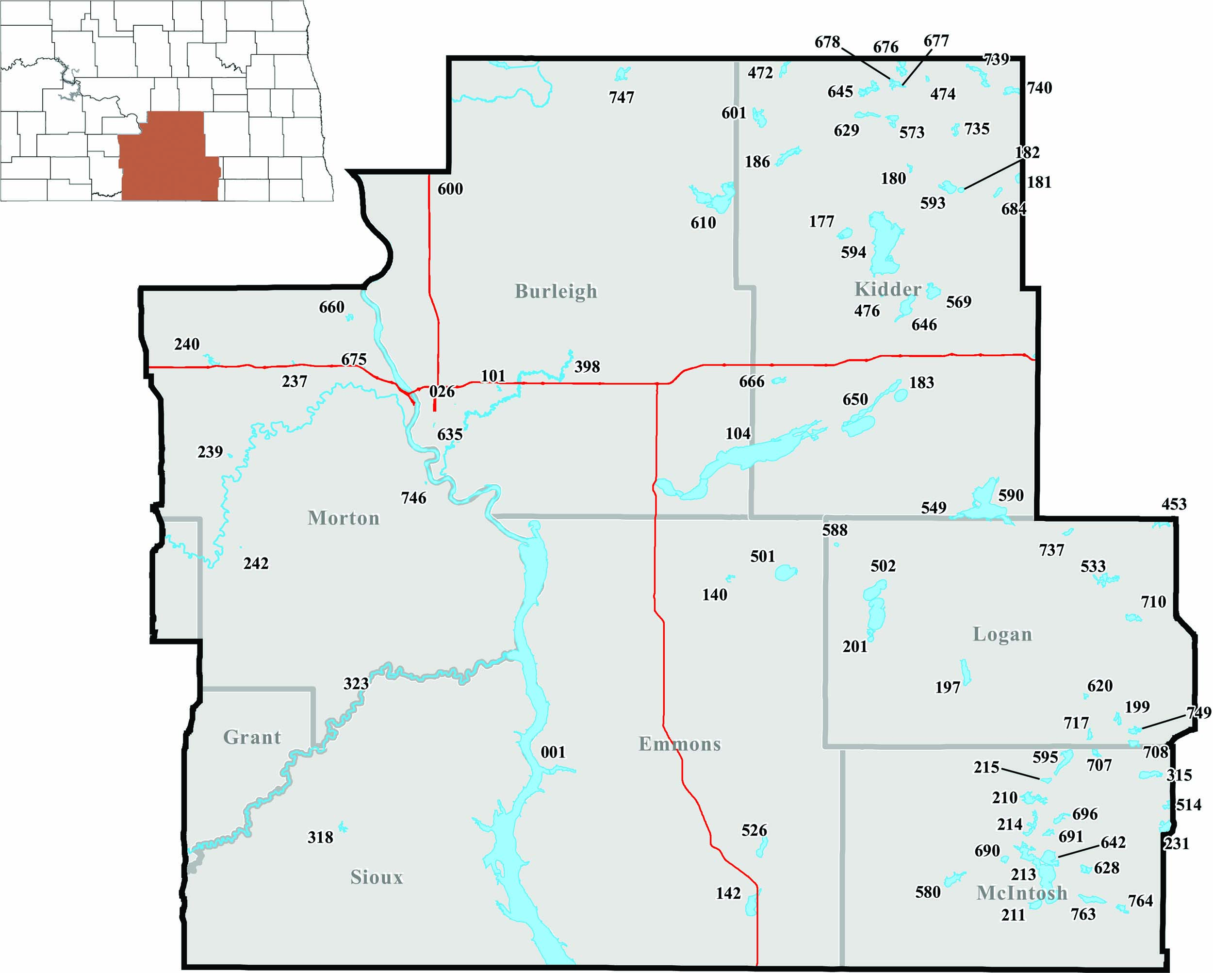
SOUTH CENTRAL FISHERIES DISTRICT
Paul Bailey, district fisheries supervisor, Bismarck
Burleigh County
- Apple Creek (398) – South central part of state. Good for northern pike, walleye, crappie and catfish. (No ramp).
- Cottonwood Park Pond (635) – On west side of Cottonwood soccer complex in south Bismarck. Adult northern pike, and other species, may be stocked in spring. (Fishing pier, no ramp).
- Crimmins WPA (747) – 3 miles west, 11 miles north, .5 miles west of Wing. Walleye abundant and low numbers of perch present. (No ramp).
- Lake Harriet (Arena Lake) (610) – 8 miles west, 1 mile south of Tuttle. Impacted by partial winterkill in 2018-19, but a fair number of northern pike present. (No ramp).
- Long Lake (104) – 1 mile south, 2.5 miles east of Moffit. Northern pike abundant. Contact refuge for specific angling regulations. (Fishing pier, no ramp).
- McDowell Dam (101) – 4 miles east, 1 mile north of Bismarck on ND Highway 10. Bluegill and largemouth bass abundant. Catchable-sized rainbow trout stocked in spring. (Fishing pier).
- OWLS Pond (026) – Just west of Bismarck Game and Fish office. Catchable-sized rainbow trout stocked in spring and fall. Other species (bluegill, perch, catfish and white bass) may be stocked. (Fishing pier, no ramp).
- Wilton City Pond (600) – South side of Wilton. Catchable-sized rainbow trout stocked in spring. (No ramp).
Emmons County
- Braddock Dam (140) – 2 miles southwest of Braddock. Fair numbers of northern pike, walleye and yellow perch. Bluegill, channel catfish and black bullheads present.
- Goose Lake (501) – 3 miles east of Braddock. Northern pike up to 8 pounds abundant and a low number of perch. (No ramp).
- Rice Lake (142) – 8 miles south of Strasburg. Walleye abundant and occasionally over 25 inches. Northern pike and perch in low numbers.
- Senger Lake (526) – 1 mile north, 6 miles east of Strasburg. Low number of perch up to 13 inches. (No ramp).
Kidder County
- Alkaline Lake (590) – 15 miles south, 7 miles east, 1.4 miles southeast of Dawson. Walleye abundant. Fair pike numbers, with fish occasionally over 10 pounds. Large perch in low numbers.
- Cherry Lake (177) – 15 miles north, 3 miles east of Steele. Small northern pike abundant. Low number of perch.
- Des Moines Lake (593) – 5.5 miles east of Robinson. Northern pike up to 5 pounds abundant. (No ramp).
- Etta-Alkaline Complex (650) – 1 mile south, 2.5 miles west, 3 miles south of Dawson. Impacted by winterkill in 2018-19, but small northern pike remain abundant. (No ramp).
- Fresh Lake (549) – 15 miles south, 7 miles east, 1 mile south of Dawson. Walleye abundant. Pike and perch present. (No ramp).
- Frettim Lake (180) – 2 miles east, 1 mile north of Robinson. Good numbers of walleye, northern pike, perch and bluegill.
- Geier Lake (740) – 12 miles east, 9.5 miles north of Robinson. Walleye abundant and a fair number of perch. (No ramp).
- Helen Lake (601) – 2.5 miles west, 6 miles north of Tuttle. An excellent northern pike fishery, with fish occasionally over 8 pounds. Perch present. (No ramp).
- Horsehead Lake (594) – 2 miles west, 8 miles south, .25 miles east of Robinson. Northern pike abundant. (No ramp).
- Jasper Lake (573) – 7 miles north, .5 miles east of Robinson. Walleye abundant and fish occasionally over 25 inches. Perch present.
- Koenig North (676) – 12.25 miles north, 1.5 miles east of Robinson. Small walleye abundant and perch present. (Winter access only, no ramp).
- Koenig South (677) – 12.25 miles north, 1.5 miles east of Robinson. Multiple perch year-classes present. (Winter access only, no ramp).
- Lake Geneva (666) – 2 miles south, .5 miles east of I-94 Exit 195. Quality walleye and perch fishery. (No ramp).
- Lake Isabel (183) – 2 miles south, .5 miles east, .75 miles south of Dawson. Small northern pike abundant.
- Lake Josephine (186) – 2 miles north of Tuttle. Walleye abundant, with fish occasionally over 25 inches. Fair number of perch and low numbers of northern pike. (Fishing pier).
- Lake No. 5 (476) – 3.5 miles west, 7.5 miles north, 1.5 miles east, 1 mile south of Dawson. Northern pike abundant, but the lake frequently winterkills. (No ramp).
- Lake Williams (182) – Just south of the town of Lake Williams. Fair numbers of walleye, northern pike and smallmouth bass.
- Long Alkaline Lake (629) – 3 miles west, 7 miles north of Robinson. Northern pike up to 4 pounds abundant. (No ramp).
- McPhail WMA (569) – 7 miles north, 2 miles west of Tappen. Perch up to 10 inches abundant. Low number of walleye. (No ramp).
- Pelican Lake (474) – 3 miles east, 11 miles north, 1 mile east of Robinson. Walleye and small perch in fair numbers. (No ramp).
- Plowe Lake (735) – 6 miles east, 5 miles north, 1 mile east of Robinson. Walleye, northern pike and perch in fair numbers. (No ramp).
- Ranch Lake (684) – 1 mile west of Pettibone. Northern pike abundant and perch present. (No ramp).
- Round Lake (181) – 1 mile north, 1.5 miles east of Pettibone. Winterkilled in 2017-18 and primarily impacted walleye. Walleye restocked in 2018. Currently holds fishable populations of northern pike and perch. (No ramp).
- Seil Lake (739) – 6 miles east, 10 miles north, 4.25 miles east of Robinson. Yellow perch abundant. (No ramp).
- Sibley Lake (646) – 7 miles north, 2 miles east, 1 mile south of Dawson. Small walleye abundant, but some fish over 20 inches. Multiple perch year-classes in good numbers.
- Swan Lake (678) – 10.5 miles north of Robinson. Small perch abundant, but fish up to 12 inches present. Low number of walleye. (No ramp).
- Willow Lake (645) – 9 miles north, 3 miles west of Robinson. Perch and small walleye in fair numbers. (No ramp).
- Woodhouse Lake (472) – 12 miles north, 12 miles east of Wing. Walleye up to 28 inches abundant. Fair number of small perch. (No ramp).
Logan County
- Beaver Lake (197) – 8 miles south, 8 miles east of Napoleon. Northern pike abundant, with fish occasionally over 10 pounds.
- Braun Lake (588) – 18 miles south, 1 mile east of Steele. Walleye and small perch abundant. (No ramp).
- Kleingartner Lake (710) – 10 miles south, 5 miles west of Gackle. Fair number of northern pike and low numbers of perch. (No ramp).
- Lepp Lake (717) – 1 mile east, 1 mile north of Lehr. Fair numbers of pike and perch. (No ramp).
- Logan Lake (453) – 1 mile west of Gackle. Walleye abundant. Fair number of small perch. (No ramp).
- Marvin Miller Lake (533) – 6.5 miles south, 8 miles west, .5 miles north of Gackle. Excellent walleye fishery, with fish occasionally over 25 inches. Fair number of perch and a low number of northern pike.
- Mundt Lake (199) – 3 miles east, 4 miles north, 1 mile east, .5 miles south of Lehr. Walleye abundant, with perch and smallmouth bass in fair numbers. (Fishing pier).
- North Napoleon Lake (502) – 4.5 miles west, 1 mile north, 1 mile east of Napoleon. Northern pike and small perch abundant. (No ramp).
- Ost Lake (749) – 7 miles east, 1 mile north, 1 mile west, .5 miles north of Lehr. Small walleye abundant. Fair number of perch. (No ramp).
- Railroad Lake (708) – 5.5 miles east of Lehr. Fair numbers of walleye and perch. (No ramp).
- Thurn Lake (620) – 5 miles north of Lehr, .5 miles east. Fair number of walleye up to 24 inches. Low number of perch. (No ramp).
- West Lake Napoleon (201) – 1 mile west of Napoleon. Northern pike abundant and a fair number of large perch. (Fishing pier, no ramp).
- Wetzel Lake (737) – 11 miles west, 1 mile south of Gackle. Small northern pike abundant. (No ramp).
Mcintosh County
- Becker-Schlepp Lake (628) – 3 miles north, 1 mile east, 1 mile north, .5 miles east of Ashley. Small perch abundant. (No ramp).
- Clear Lake (215) – 6 miles east, 2 miles south of Wishek. Small northern pike abundant. (No ramp).
- Dollinger-Schnabel Lake (580) – 2 miles north, 5 miles west, 3 miles north of Venturia. Fair number of perch up to 12 inches and small walleye abundant. (No ramp).
- Dorfman Lake (642) – 5 miles north, 2 miles west of Ashley. Walleye abundant, along with a fair number of pike and perch. (No ramp).
- Dry Lake (213) – 5 miles west, 4 miles north, 2 miles east, .5 miles south of Ashley. Excellent walleye and pike fishery, with a low number of large perch.
- Green Lake (210) – 2 miles east, 4 miles south, 1 mile east of Wishek. Quality walleye and perch fishery, with a low number of pike. (Fishing pier).
- Harr Lake (514) – 10 miles east, 12 miles north of Ashley. Walleye abundant and low numbers of large yellow perch. (No ramp).
- Homestead Lake (696) – 8 miles south, 8 miles east, 2 miles north of Wishek. Small northern pike abundant. (No ramp).
- Kislingbury Lake (763) – .5 miles east, 1.5 miles north of Ashley. Walleye abundant and perch in low numbers.
- Lake Hoskins (211) – 3 miles west of Ashley. Fair numbers of walleye, northern pike and yellow perch. (Fishing pier).
- McIntosh WMA (231) – 10 miles east, 9 miles north of Ashley. Low numbers of perch and walleye. (No ramp).
- Miller Lake (315) – 7.5 miles east, 2.5 miles south of Lehr. Fair numbers of northern pike and small perch. (No ramp).
- Mudd Lake (595) – 1 mile west of Lehr. Fair number of northern pike and a low number of perch. (No ramp).
- Nagel Lake (Koepplin WPA) (707) – 1.5 miles east, .5 miles south of Lehr. Walleye abundant and a low number of perch. (No ramp).
- Pfeifle Lake (690) – 10 miles south, 2 miles east of Wishek. Northern pike, perch and walleye in fair numbers. (No ramp).
- Pintail Lake (764) – 5 miles east of Ashley. Low number of perch. (No ramp).
- Pudwill Lake (214) – 9 miles south, 4 miles west, 1 mile north, .5 miles west of Lehr. Low numbers of northern pike, walleye and perch. (No ramp).
- Rueb-Eszlinger (691) – 7.5 miles north, 2 miles west of Ashley. Multiple perch year-classes abundant. (No ramp).
Morton County
- Crown Butte Dam (237) – 4 miles west on access road on north side of I-94 Exit 147. Complete winterkill in 2019. Catchable-sized trout and bluegill stocked. (Fishing pier).
- Fish Creek Dam (239) – 8 miles south, 2 miles east, 1 mile south of I-94 Exit 134. Largemouth bass and rainbow trout abundant. Smallmouth bass, brown trout and crappie in lower numbers. (Fishing pier).
- Harmon Lake (660) – 8 miles north of Mandan on ND Highway 1806. Largemouth bass, bluegill and crappie abundant. Rainbow trout and northern pike in lower numbers. (Fishing pier).
- Little Heart Pond (746) – 11 miles south of Mandan on ND Highway 1806. Catchable-sized rainbow trout stocked in spring. (No ramp).
- Nygren Dam (242) – 6 miles north, 1 mile east, 3 miles north, .5 miles east of Flasher. Catchable-sized trout stocked in spring, small bluegill and 10- to 14-inch largemouth bass abundant. (Fishing pier).
- Porsborg Dam (675) – Northwest Mandan. Rainbow trout (and other species) may be stocked in spring. (No ramp).
- Sweet Briar Lake (240) – 18 miles west of Mandan I-94 Exit 134. Fair numbers of walleye, pike, perch, bluegill, crappie and largemouth bass. (Fishing pier).
Sioux County
- Froelich Dam (318) – 9 miles north, 2 miles west of Selfridge. Walleye and northern pike abundant. Yellow perch, crappie, bluegill and largemouth bass present.
 Click for a larger image.
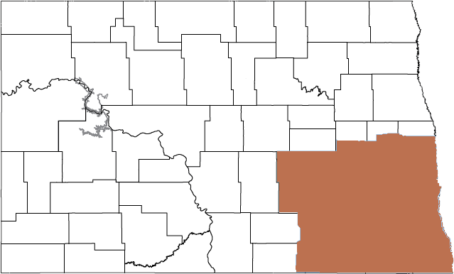
SOUTHEAST FISHERIES DISTRICT
Brandon Kratz, district fisheries supervisor, Jamestown
Barnes County
- Blumers Pond (023) – 1 mile south of Valley City. Perch and bluegill abundant. (No ramp).
- Clausen Springs (051) – 3 miles north, 1 mile east, .5 miles north of the junction of ND highways 46 and 1. Largemouth bass and bluegill abundant. Occasional perch. (Fishing pier).
- Clauson Lake (704) – 4 miles west, .5 miles south, .5 miles east of Nome. Low density perch population. (No ramp).
- Eckelson Lake North (605) – 3 miles north, .5 miles east, 1 mile north, .5 miles east of Eckelson. Perch abundant, with some larger fish. (No ramp).
- Eckelson Lake South (671) – 4 miles south, 1.5 miles east of Eckelson. Low number of pike. Moderate number of perch. (No ramp).
- Fox Lake (586) – 1 mile north, .75 miles west of Eckelson. Walleye and perch abundant, with some larger fish.
- Hatchery Kids Pond (064) – 2 miles northwest of Valley City. Various fish species, including rainbow trout stocked in spring. (No ramp).
- Hobart Lake North (636) – 3.5 miles northwest of I-94 Exit 288. Perch abundant, with some large fish. (No ramp).
- Hobart Lake South (532) – 1.4 miles south, 3.4 miles west of I-94 Exit 288. Perch abundant. (No ramp).
- Island Lake (672) – 3 miles south, .5 miles east of Urbana. Walleye abundant. Moderate number of perch. Seasonal boat use restrictions. (No ramp).
- Kee Lake (606) – 7 miles south, 2 miles east of Eckelson. Walleye abundant. Moderate number of perch. Occasional pike. (No ramp).
- Koebernick Pond (602) – 1 mile north, 4 miles west, 1 mile north of Rogers. Moderate number of perch. (No ramp).
- Lake Ashtabula (046) – 10 miles north of Valley City. Walleye, pike and smallmouth bass abundant. Good number of larger fish. Moderate number of perch. Occasional crappie, white bass and bluegill. Muskellunge present. (Fishing pier).
- Meadow Lake (565) – 6 miles west, 6 miles north of Litchville. Moderate number of perch, with some larger fish. Low density walleye population. (No ramp).
- Middle Eckelson (670) – 2 miles east of Eckelson. Low density pike population. Moderate number of perch. (No ramp).
- Moon Lake (049) – 2 miles west, 5.5 miles south, 4 miles west, 2 miles north of Valley City. Walleye and perch abundant. Occasional smallmouth bass, brown and/or rainbow trout.
- Mosher WPA (564) – 2.5 miles north, 4.5 miles east of Dazey. Walleye abundant. (No ramp).
- Olson WPA (633) – 1.5 miles north of I-94 Exit 283. Moderate number of perch. (No ramp).
- Sanborn Lake (557) – 2 miles east, 1 mile north, .5 miles east of Sanborn. Moderate number of pike. (No ramp).
- Sanborn WPA (567) – 1 mile east of Sanborn. Moderate numbers of pike and perch. (No ramp).
- St. Mary’s Lake (045) – 2 miles west, 5.5 miles south, 4 miles west, 1 mile north of Valley City. Walleye and perch abundant. (No ramp).
- Sweetwater Lake (052) – 4 miles south, 1 mile east of Sanborn. Moderate numbers of crappie, perch and walleye. (No ramp).
Cass County
- Brewer Lake (111) – 1 mile south, 1 mile west of Erie. Largemouth bass and bluegill abundant. Some larger bass. Occasional walleye and crappie. (Fishing pier).
- Brooks Harbor (326) – .5 miles south, .5 miles west of I-94 Exit 346. Rainbow trout and perch present. (No ramp).
- Casselton Pond (219) – Southeast corner of Casselton. Rainbow trout stocked annually in late spring. (No ramp).
- Lindemann Lake (703) – 2 miles north, 1 mile east, .5 miles north of Enderlin. Walleye and perch abundant. (No ramp).
- North Woodhaven Pond (656) – 2.25 miles south, .25 miles east of I-94 Exit 348. Rainbow trout stocked annually in spring. (Fishing pier, no ramp).
- South Woodhaven Pond (673) – 2.8 miles south, .25 miles east of I-94 Exit 348. Perch present. (Fishing pier, no ramp).
Dickey County
- Heinrich Lake (611) – 17.5 miles east, 1 mile south of Ashley. Low density perch population. (No ramp).
- Hofer Lake (145) – 7 miles east, 1.75 miles north of Ellendale. No recent information. (No ramp).
- Moores Lake (119) – 18.5 miles west, 1 mile north of Ellendale. Moderate numbers of pike and perch. (No ramp).
- Pheasant Lake (120) – 6 miles west of Ellendale. Moderate number of pike, perch, bluegill, crappie, catfish and walleye. (Fishing pier).
- Shimmin Lake (531) – 20.5 miles west, 1 mile south of Ellendale. Pike abundant. (No ramp).
- Whitestone Lake (122) – .5 miles south, 1.5 miles west, 1 mile south of Merricourt. Abundant perch. Occasional bluegill. (No ramp).
- Wilson Dam (121) – 7.5 miles west of Monango. Moderate numbers of perch, pike and bluegill. (Fishing pier).
Lamoure County
- Alfred Lake (574) – 7 miles east, 1.5 miles south of Gackle. Low pike and perch populations. (No ramp).
- Boom Lake (Marion Lake) (561) – .5 miles west of Marion. Moderate numbers of pike and walleye.
- Cottonwood Lake (192) – 5 miles west, 5 miles south, 1 mile west of LaMoure. Moderate number of pike. (No ramp).
- Diamond Lake (553) – 5 miles north of Kulm. Walleye and perch abundant. Moderate number of pike.
- Heinrich-Martin Dam (189) – .75 miles east, .5 miles south of Adrian. Largemouth bass and bluegill abundant. Moderate numbers of crappie, perch and pike.
- Kalmbach Lake (194) – .5 miles south, 4.5 miles west, .5 miles south of Jud. Pike abundant.
- Kulm-Edgeley Dam (191) – 4 miles west, 2 miles south of Edgeley. Moderate numbers of pike, bluegill and perch. Low number of walleye.
- Lake LaMoure (196) – 1 mile south, 1 mile east, 2.5 miles south, 1 mile west, .5 miles south of LaMoure. Pike and crappie abundant. Moderate numbers of walleye and perch. Occasional bluegill. (Fishing pier).
- Limesand-Seefeldt Dam (193) – 8 miles south, 3 miles west of Marion. Pike abundant. Moderate numbers of bluegill, perch and crappie.
- Schlecht-Thom Dam (195) – 5 miles west, .5 miles north of Edgeley. Moderate numbers of pike and bluegill.
- Schlenker Dam (Lehr Dam) (422) – 11 miles west, .5 miles south of the junction of U.S. Highway 281 and ND Highway 46. Moderate numbers of pike and bluegill.
- Twin Lakes (552) – 4 miles north of LaMoure. Walleye, pike and perch abundant. Some larger fish.
Logan County
- Arnies Lake (623) – 1.5 miles south of Gackle, 2 miles east, 1 mile south. Moderate numbers of pike, perch and walleye. (No ramp).
- Erickson Lake (722) – 8.5 miles north, 3 miles west, 1 mile north, 1.5 miles west, .5 miles south of Kulm. Perch abundant, with some larger fish. (No ramp).
- Oriole Lake (267) – 8.25 miles south of Gackle. Pike abundant. (No ramp).
Mcintosh County
- Berlin Lake (779) – 9.5 miles east, 7 miles north, 2 miles east, 2 miles north of Ashley. Perch present. (No ramp).
- Blumhardt Dam (208) – 9.5 miles east, 7 miles north, 1.5 miles east of Ashley. Brown and rainbow trout.
- Coldwater Lake (209) – 15.5 miles east, 1 mile south, 1 mile west of Ashley. Moderate numbers of walleye and pike, with some larger fish. (Fishing pier).
- Serpent Lake (781) – 13.5 miles east, 2 miles north, 1 mile east of Ashley. Moderate numbers of pike and perch. (No ramp).
Ransom County
- Dead Colt Creek (284) – 5 miles south, 1 mile east, .5 miles north, .5 miles east of Lisbon. Largemouth bass, bluegill and crappie abundant. Some larger bass. (Fishing pier).
- Lone Tree Lake (Englevale) (283) – .5 miles north, 2 miles west of Englevale. Moderate number of perch. Pike present. Substantial winterkill 2018-19. (No ramp).
- Mooringstone Pond (281) – .75 miles west of the city of Fort Ransom. Rainbow trout stocked annually in late spring. (No ramp).
Richland County
- Elm Lake (693) – .5 miles east, 3.5 miles south of Lidgerwood. Walleye abundant. Moderate number of pike. (No ramp).
- Four Corners Lake (727) – 3.5 miles east, 2 miles south, .5 miles west of Lidgerwood. Low density walleye and perch populations. (No ramp).
- Gullys Slough (572) – 4 miles east, 1 mile south of Lidgerwood. Moderate numbers of pike and walleye. (No ramp).
- Haus Lake (745) – 2 miles east, 7 miles south, .25 miles east of Lidgerwood. Moderate number of walleye. Occasional perch. (No ramp).
- Horseshoe Lake (287) – 4 miles west, 1 mile south of Hankinson. Moderate numbers of pike, perch, bluegill and walleye. Some larger walleye.
- Lake Elsie (289) – 1 mile south, 1.5 miles west of Hankinson. Walleye and crappie abundant. Moderate numbers of smallmouth bass, bluegill and perch. Occasional catfish. 14-inch minimum length limit on walleye. (Fishing pier).
- Lueck Lake (622) – 6 miles east, 2.5 miles south of Lidgerwood. Walleye abundant, with some larger fish. (No ramp).
- Mooreton Pond (288) – 2 miles east of Mooreton. Rainbow trout stocked annually in late spring. Moderate number of walleye. Occasional perch, bass, crappie and channel catfish. (Fishing pier).
- Reiland Lake (729) – 3 miles north, .5 miles east of Lidgerwood. Walleye abundant. Moderate number of perch. (No ramp).
- Shriner Lake (754) – 4.5 miles south, .25 miles east of Lidgerwood. Moderate numbers of pike and perch. Occasional walleye and crappie. (No ramp).
- Vislisel Lake (728) – 1 mile north, 2 miles east, 1 mile north, 1 mile west of Lidgerwood. Walleye and perch abundant. (No ramp).
- Wahl Lake (523) – 1 mile east, 2 miles south of Lidgerwood. Walleye and bluegill abundant. Occasional pike. (No ramp).
- West Moran Lake (669) – 2 miles east, .5 miles south of Lidgerwood. Walleye abundant. (No ramp).
Sargent County
- Alkali Lake (302) – 3 miles south of Cayuga. Low density walleye population. Crappie abundant.
- Bergh Slough (647) – 1 mile south, 2.5 miles east of Forman. Perch and pike present. (No ramp).
- Buffalo Lake (307) – 6 miles north, 1 mile east of Rutland. Moderate numbers of walleye and pike, and the occasional crappie. 14-inch minimum walleye length limit.
- Consolidated Lake (651) – 2 miles south, 3 miles east of Forman. Moderate numbers of pike, walleye and largemouth bass. Crappie present. (No ramp).
- Deuce Lake (257) – 1.5 miles south, 1 mile east, .25 miles south of Forman. Moderate numbers of pike and crappie. Minor winterkill in 2018-19. (No ramp).
- Fiala Lake (571) – 1 mile west, 2 miles south of Forman. Moderate number of pike, with some larger fish. Winterkilled 2018-19. (No ramp).
- Kraft Slough (643) – 1 mile south, 9 miles east, 2.5 miles north of Oakes. Walleye and perch abundant.
- Lake Tewaukon (305) – 5 miles south of Cayuga. Contact Tewaukon National Wildlife Refuge for most recent information. (Fishing pier).
- Lake Walstead (667) – 4 miles south, 1 mile east, 1 mile north of Forman. Walleye abundant. Moderate number of pike. (No ramp).
- Nelson Lake (313) – 4.5 miles south, .5 miles east of Forman. Pike abundant. Moderate numbers of perch and walleye. (No ramp).
- Ole Breum Lake (744) – 5 miles north, 1 mile east of Rutland. Moderate number of pike. Low number of perch. Occasional walleye and crappie. (No ramp).
- Silver Lake (303) – 3 miles west, 2 miles south of Rutland. Moderate number of walleye. (Fishing pier).
- Sprague Lake (309) – 6 miles west, 4 miles south, 1.5 miles west of Cayuga. Fair number of walleye.
- Tosse Slough (679) – 7.5 miles south, 1 mile east, 2 miles south, 1 mile east of Geneseo. Low numbers of pike and walleye. Some larger pike.
Stutsman County
- Alkali Lake (539) – 11 miles north, 5 miles east, .5 miles south of Jamestown. Good numbers of pike, perch and walleye. Some larger walleye and pike. (No ramp).
- Bader Lake (427) – 4 miles south, 1 mile east of I-94 Exit 230. Moderate numbers of walleye and pike.
- Barnes Lake (346) – 1 mile east, 6 miles north of Woodworth. Walleye abundant. Moderate number of pike.
- Big Mallard Marsh (599) – 9 miles north, 2.5 miles east of Woodworth. Walleye abundant. Low pike density.
- Brooks Complex (797) – 4 miles south, 2 miles east, 2 miles south, .5 miles west of Cleveland. (No ramp).
- Clark Lake (340) – 1 mile west, 3 miles north, 4 miles west of Woodworth. Moderate numbers of walleye and pike. Occasional perch.
- Cleveland Slough (665) – .5 miles south of Cleveland along County Road 67. Perch abundant. Occasional large pike. (No ramp).
- Crystal Springs (179) – 1 mile east of Crystal Springs. Walleye and pike abundant.
- Cysewski Lake (148) – 11 miles north, 4 miles east, 2 miles north, .5 miles east, 1 mile north of Jamestown. Perch abundant. Pike present. (No ramp).
- East Easter Lake (782) – 5 miles north, 4 miles east, 1 mile south of Streeter. Perch abundant, with some larger fish. (No ramp).
- Foot Lake (321) – 2 miles south, 4 miles west of Medina. Walleye abundant. Perch present. (No ramp).
- Gaier Lake (784) – 8.5 miles north, 1 mile west of Cleveland. Low density perch population. (No ramp).
- Hehn-Schaffer Lake (459) – 4 miles north of Gackle. Moderate numbers of pike, perch and walleye. (Fishing pier).
- Hieb Lake (786) – 3.5 miles east, 6 miles north, 1 mile east of Medina. Moderate number of perch. (No ramp).
- Hoggarth Dam (576) – 3 miles west, 3 miles south of Courtenay. Walleye abundant, with the occasional perch. (No ramp).
- Jamestown Reservoir (341) – 2 miles north of Jamestown. Moderate numbers of pike and walleye. Crappie abundant. Occasional perch and smallmouth bass. 14-inch minimum walleye length limit. (Fishing pier).
- Little Britches Pond (492) – Next to Jamestown Reservoir marina. Late spring rainbow trout, crappie and perch. Occasional walleye and pike. (No ramp).
- Manley Lake (631) – 4 miles south, 9 miles west, .25 miles north of Pingree. Moderate number of perch. (No ramp).
- Mud and Pearl Lakes (730) – 10 miles north, 2.5 miles west of Medina. Perch abundant, with some larger fish. Small walleye. (No ramp).
- Paris Lake (789) – 8 miles east, 3.5 miles south of Woodworth. Moderate number of perch. (No ramp).
- Pipestem Reservoir (348) – 5 miles northwest, .8 miles west, 1 mile south of Jamestown. Severe winterkill in 2018-19.
- R and M Lake (579) – 4 miles east, 5 miles north of Buchanan. Walleye abundant. Moderate number of perch. (No ramp).
- Reule Lake (607) – 2 miles north, 5 miles west, 1.7 miles south of Medina. Walleye abundant. Moderate number of perch. (No ramp).
- Schock Lake (592) – 11 miles north, 3.5 miles east, 1 mile north, .5 miles west of Jamestown. Perch abundant. (No ramp).
- School Lake (790) – 5 miles north, 5 miles east, 3 miles north of Streeter. Perch abundant. (No ramp).
- Spiritwood Lake (343) – 11 miles north, 4 miles east of Jamestown. Smallmouth bass abundant. Moderate numbers of walleye and perch. Low number of pike. (Fishing pier).
- Stink Lake (766) – 2.5 miles east of Crystal Springs. Walleye and perch abundant. Occasional large pike. (No ramp).
- Stirton Lake (792) – 3 miles south of Cleveland. Walleye abundant. Some perch present. (No ramp).
- Streeter Lake (460) – South side of Streeter. Low density large pike population.
- Trautman Slough (793) – 4 miles south, 2 miles west, 1 mile south of Cleveland. Walleye abundant. Occasional perch. (No ramp).
- Wanzek Slough (414) – .5 miles west, 1 mile south, .75 miles west of Windsor. Pike, perch and small walleye present. (No ramp).
- Zimmerman Lake (796) – 2 miles north of Cleveland. Perch abundant. (No ramp).
Rivers and Lakes
- Bois de Sioux River (412) – Southeast corner of state in Richland County. Good catfish and walleye populations. (No ramp).
- James River (400) – Southeastern part of state. Shore-fishing opportunities where lowhead dams and bridge crossings congregate pike and walleye.
- Red River (411) – Eastern edge of state. Catfish abundant. Some larger fish common. Moderate number of walleye, with some larger fish. (Fishing pier).
- Sheyenne River (397) – Southeastern part of state. Smallmouth bass abundant. Moderate numbers of walleye and catfish. (Fishing pier).
- Wild Rice River (409) – Southeastern part of state. Moderate numbers of catfish, walleye and pike. (No ramp).
MISSOURI RIVER SYSTEM
Dave Fryda, Missouri River System supervisor, Riverdale
NORTHERN PIKE
- Lake Sakakawea/Lake Oahe – Northern pike abundance in Lake Sakakawea has declined from record highs the last couple years, but still remains exceptional. However, the population is maturing and average size is increasing. Pike exceeding 15 pounds will become more common in 2020 and the next few years. Pike abundance has declined in Lake Oahe from recent years, but average size is excellent, with fish occasionally over 20 pounds.
WALLEYE
- Lake Sakakawea – Walleye fishing was good in 2019 and should remain so in 2020. High forage abundance and good habitat conditions have allowed Sakakawea walleye to maintain good body condition, good growth rates and high abundance. Overall walleye abundance is the highest documented in the last 45 years due to several recent strong year-classes. Anglers will find excellent numbers of 15- to 20-inch fish in 2020, with good numbers of larger fish.
- Missouri River/Lake Oahe – The fishery downstream of Garrison Dam to the South Dakota border was greatly impacted following the flood of 2011. The Garrison Reach of the Missouri River upstream of Bismarck has been slow to recover and still suffers from depressed forage conditions. Walleye reproduction was good from 2014-16, so smaller walleye are present in good numbers and this fishery continues to provide opportunity for trophy-sized fish. Fortunately, the upper Oahe fishery recovered much better than the Garrison Reach. Forage conditions have improved and walleye growth rates have followed. Walleye reproduction was very good from 2014-16, so smaller walleye are abundant and larger fish present.
CATFISH
- Upper Lake Sakakawea, Missouri River and Yellowstone River – A strong catfish population, with some fish exceeding 10 pounds.
- Lake Sakakawea – Good population of catfish throughout the reservoir, but the best numbers and fishing success are in the upper end.
- Garrison Dam Tailrace – Provides some good fishing for smaller catfish, especially in summer. Cats from this area are great table fare due to the relatively cold water throughout summer.
- Missouri River, south of Garrison Dam – Channel catfish are abundant and underutilized throughout the entire reach.
SALMON
- Missouri River System – The Missouri River salmon fishery was greatly affected by high water in 2011, but recovered and salmon fishing in 2016-17 was good, but somewhat slower in 2019. Fall spawning operations in 2019 found low numbers of fish in Sakakawea, but very high numbers in the Garrison Tailrace. Extremely high releases from the dam, and with the emergency spillway running well into fall 2019, resulted in very high entrainment of salmon and other fish through Garrison Dam. It is unknown how this high entrainment will impact Sakakawea’s salmon fishery in 2020 and the next couple years.
SMALLMOUTH BASS
- Lake Sakakawea – The smallmouth bass population remains good and anglers will continue to encounter good numbers of fish. The population also contains good numbers of whopper-sized fish.
TROUT
- Garrison Dam Tailrace – Continues to produce trophy brown and rainbow trout. The Tailrace is a diverse quality fishery, not only for trout, but for walleye and salmon.
DEVILS LAKE BASIN
Randy Hiltner, district fisheries supervisor, and Todd Caspers, fisheries biologist, both Devils Lake
WALLEYE
- Devils Lake – Walleye population continues to do well. Reproduction in recent years has generally been good and there are many fish less than 15 inches. The number of 15- to 20-inch walleye is below average due to three consecutive year-classes that were relatively low from 2013-15. There are still fish in this size range, but anglers will have to fish longer to catch them. The number of walleye longer than 20 inches is similar to the long-term average.
- Stump Lake – Walleye population is doing well. There are a variety of sizes available, with good numbers of fish. The numbers of fish from 15-20 inches is a bit below average, but other size groups that anglers would be interested in are all above average.
- Lake Irvine – Boat access conditions currently very poor, as the makeshift boat launch site a few miles north of Churchs Ferry is essentially unusable and likely will remain so unless water levels rise significantly. Walleye population continues to do relatively well, but the number of 15- to 25-inch fish is below average.
NORTHERN PIKE
- Devils Lake – Northern pike will continue to provide good angler opportunities in 2020. Pike continue to reproduce naturally, are relatively abundant and can be found throughout the lake, particularly in shallower areas. Most fish are between 24-30 inches, but trophy-sized pike are available. Pike are underutilized, so anglers should not be shy about keeping their limit.
- Stump Lake – Northern pike numbers are below average, but fish are still relatively abundant. Most pike are between 26-30 inches, but there are smaller and larger fish present.
- Lake Irvine – Northern pike numbers are below average, but fish are still abundant. Most pike are medium-sized, but there are some larger fish. Pike in Lake Irvine are underutilized, so anglers should not be shy about keeping their limit. In fact, pike seem to be too abundant, as their body condition has declined, so keeping pike from this lake would be beneficial for the population as it may help reduce competition for food.
YELLOW PERCH
- Devils Lake – The number of catchable-sized yellow perch is lower than last year. The number of perch from 8-12 inches is below the long-term average. The number of jumbos over 12 inches is also below average. The number of perch smaller than 8 inches is below average as well. Overall, there should be perch for anglers to pursue in 2020, but numbers are below average.
- Stump Lake – Yellow perch numbers seem to be lower. All size-classes that anglers would be interested in seem to be below average. Overall, there should still be perch fishing opportunities in 2020, but fishing may be slower than usual.
- Lake Irvine – Yellow perch numbers are low, but the few perch in the lake tend to be larger.
WHITE BASS
- Devils Lake – White bass numbers are high. Most were hatched in 2015 and will likely be between 13-15 inches in 2020.
- Stump Lake – White bass numbers seem to be lower than the last couple of years, but fish are still relatively abundant. Most bass will likely be between 14-16 inches in 2020.
- Lake Irvine – White bass numbers are low, but they tend to be good sized.