

Map Index
The following maps and applications are produced by the North Dakota Game and Fish Department. Maps may be viewed using a browser. Interactive maps can also be accessed using the ArcGIS Explorer mobile app.
| Link | Format | Description | Category |
|---|---|---|---|
| Boating Access | Interactive | Boat access points on fishing waters - includes ramp type |
Boating |
| Where to Fish App | Interactive | App for searching fishing and boating maps. |
Boating, Fishing |
| Fishing Waters Viewer | Interactive | Fishing waters maps including lake contours |
Fishing |
| Paddlefish Snagging Areas | Interactive | Paddlefish snagging areas |
Fishing |
| Statewide Fishing Waters Poster | Statewide fishing waters poster (12.4MB) |
Fishing | |
| Where to Fish App | Interactive | App for searching fishing and boating maps. |
Boating, Fishing |
| All Hunting Units (List of Interactive Maps) | Interactive | All Hunting Units (List of Interactive Maps) |
Hunting, Hunting and Trapping Units/Zones |
| Bighorn Sheep Hunting Units | Interactive | Bighorn Sheep hunting units |
Hunting and Trapping Units/Zones |
| Bobcat Hunting Zones | Interactive | Bobcat hunting zones |
Hunting and Trapping Units/Zones |
| Canada Goose Hunting Zones Map | Interactive | Canada goose hunting zones |
Hunting and Trapping Units/Zones |
| Deer Hunting Units | Interactive | Deer hunting units |
Hunting and Trapping Units/Zones |
| Ducks High Plains and Low Plains Units | Interactive | Ducks high plains/low plains hunting units |
Hunting and Trapping Units/Zones |
| Elk Hunting Units | Interactive | Elk hunting units |
Hunting and Trapping Units/Zones |
| Fisher Hunting Zones | Interactive | Fisher hunting zones |
Hunting and Trapping Units/Zones |
| Moose Hunting Units | Interactive | Moose hunting units |
Hunting and Trapping Units/Zones |
| Mountain Lion Hunting Zones | Interactive | Mountain lion hunting zones |
Hunting and Trapping Units/Zones |
| Nonresident Waterfowl Zones | Interactive | Nonresident waterfowl hunting zones |
Hunting and Trapping Units/Zones |
| Pronghorn Hunting Units | Interactive | Pronghorn hunting units |
Hunting and Trapping Units/Zones |
| Ruffed Grouse Hunting Units | Interactive | Ruffed grouse hunting units |
Hunting and Trapping Units/Zones |
| Sandhill Crane Hunting Units | Interactive | Sandhill crane hunting units |
Hunting and Trapping Units/Zones |
| Sharp-Tailed Grouse Hunting Units | Interactive | Sharp-tailed grouse hunting unit map |
Hunting and Trapping Units/Zones |
| Wild Turkey Hunting Units - Fall | Interactive | Wild turkey fall season hunting units |
Hunting and Trapping Units/Zones |
| Wild Turkey Hunting Units - Spring | Interactive | Wild turkey spring season hunting units |
Hunting and Trapping Units/Zones |
| Enforcement Districts | Interactive | North Dakota Game and Fish Department enforcement districts |
NDGF Admin Districts |
| General Information Viewer | Interactive | Admin. districts, hunting and management units, fisheries and wildlife data, etc. |
NDGF Admin Districts, Miscellaneous |
| Private Lands Initiative Districts | JPG | North Dakota Game and Fish Department private lands initiative districts |
NDGF Admin Districts |
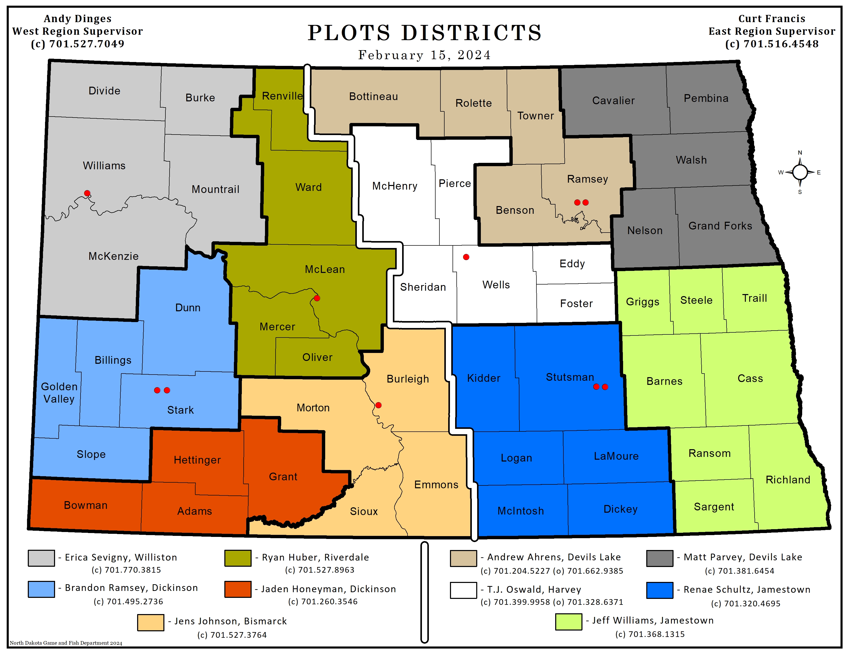
| PLOTS Guide Map Sheets | PLOTS Guide map sheets |
PLOTS | |
| Greater-Prairie Chicken Range | Interactive | Greater-prairie chicken range |
Species Range |
| Hungarian Partridge Range | Interactive | Hungarian Partridge range map |
Species Range |
| Muskrat Range | Interactive | Muskrat primary and secondary range. |
Species Range |
| Ring-necked Pheasant Range | Interactive | Ring-necked pheasant range map. |
Species Range |
| River Otter Range | Interactive | River otter primary and secondary range. |
Species Range |
| Snow Goose Range - Fall | Interactive | Snow goose fall range |
Species Range |
| White-Fronted Goose Range | Interactive | White-fronted geese range |
Species Range |
| Wildlife Management Areas | Interactive | Wildlife management areas |
WMA |
| CREP II Riparian Project Boundary | Interactive | CREP II riparian project boundary |
Miscellaneous |
| General Information Viewer | Interactive | Admin. districts, hunting and management units, fisheries and wildlife data, etc. |
NDGF Admin Districts, Miscellaneous |
| WMA Shooting Ranges | Interactive | North Dakota Game and Fish Department managed public shooting ranges |
Miscellaneous |
| All Hunting Units (List of Interactive Maps) | Interactive | All Hunting Units (List of Interactive Maps) |
Hunting, Hunting and Trapping Units/Zones |
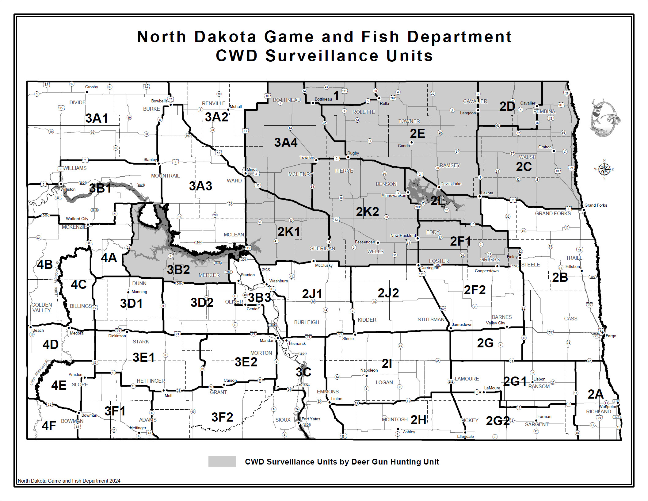
| CWD Surveillance Units | JPG | CWD surveillance units |
Hunting |
| Deer Head Collection Sites (Updated Annually Prior to Deer Season) | Interactive | Locations of deer head collection sites. This map is updated annually prior to deer season start. |
Hunting |
| Hunting Atlas | Interactive | Hunting - Species and lands information |
Hunting |
| Private Lands Initiative CRP SAFE | Interactive | Private Lands Initiative CRP SAFE |
Conservation |
| Electronically Posted Lands | Interactive | Electronically posted private lands and associated information (zoom in on map to show the electronic posting layer) |
Electronically Posted Private Lands |